
Midwest Winter Storm Dumps Over 11 Inches of Snow Across Iowa, With Heavy Snow Continuing in Illinois and Wisconsin
ILLINOIS — A major winter storm sweeping across the Midwest has delivered significant snowfall totals, with Iowa seeing accumulations over 11 inches and snow continuing to fall across parts of Illinois, Wisconsin, and Minnesota this afternoon.
According to early reports, Iowa Falls and Fort Dodge, Iowa, lead the region with 11.0 inches of snow as of midday Saturday, while several nearby towns reported between 7 and 10 inches. Forecasters say the system still has several hours of heavy snow left to go, particularly for northern Illinois and southern Wisconsin, where totals are expected to climb further overnight.
Heaviest Snow Concentrated in Central Iowa
The storm intensified overnight Friday into Saturday morning, producing bands of heavy, wet snow across central and eastern Iowa. Snowfall rates at times exceeded one inch per hour, causing dangerous driving conditions and reduced visibility across interstates I-35, I-80, and U.S. 20.
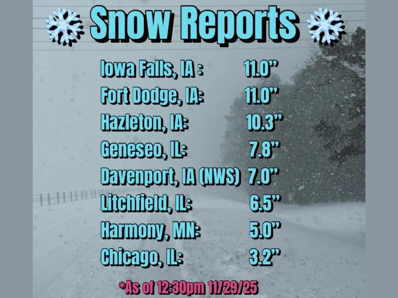
Reported totals as of 12:30 p.m. Saturday include:
- Iowa Falls, IA: 11.0 inches
- Fort Dodge, IA: 11.0 inches
- Hazleton, IA: 10.3 inches
- Davenport, IA (NWS): 7.0 inches
- Geneseo, IL: 7.8 inches
- Litchfield, IL: 6.5 inches
- Harmony, MN: 5.0 inches
- Chicago, IL: 3.2 inches
Meteorologists note that the heaviest snow bands have now shifted east into northern Illinois and southern Wisconsin, where another 2–5 inches is possible before the system tapers off late tonight.
Illinois and Wisconsin Seeing Increasing Totals
In Illinois, snow began early Saturday morning and intensified through midday, coating roadways from the Quad Cities to Chicago.
By early afternoon, Geneseo had recorded nearly 8 inches, while Chicago had picked up just over 3 inches — a number expected to rise as the storm continues through the evening.
Snowfall will persist into Saturday night, with Milwaukee, Rockford, and Madison expected to see 4–7 additional inches before tapering off by early Sunday morning.
Travel Conditions and Safety Advisory
The National Weather Service continues to warn of hazardous driving conditions due to snow-covered roads and reduced visibility. Motorists are urged to avoid unnecessary travel and allow extra time if driving through impacted areas.
Snowplow crews remain active across interstates and highways, but road surfaces may remain slippery through Sunday morning, especially on untreated routes.
Cold Air and Blowing Snow to Follow
Behind the storm, temperatures will fall sharply, and gusty northwest winds could lead to drifting and blowing snow, particularly in open rural areas of Iowa and northern Illinois. Wind chills are expected to drop into the single digits by Sunday morning.
Meteorologists say this storm marks one of the most significant snow events so far this season for the region, providing a much-needed boost for seasonal snowpack while also complicating post-holiday travel.
For continued Midwest weather coverage and community alerts, stay updated with NapervilleLocal.com.

I’ve lived in Naperville long enough to see how quickly our community changes — from new developments downtown to sudden shifts in our Midwest weather. Reporting on Naperville news and daily forecasts gives me the chance to keep neighbors informed about what really matters. My goal is simple: deliver clear, timely updates so you always know what’s happening in our city and what to expect from the skies above.