
Minnesota, Iowa, South Dakota, and Illinois Brace for Dangerous 70 MPH Winds and Ground Blizzard Conditions
MIDWEST UNITED STATES — Meteorologists are sounding the alarm for a potentially hazardous weather setup across Minnesota, Iowa, South Dakota, and Illinois beginning Wednesday, as a powerful storm system combines with existing snowpack to create life-threatening travel conditions.
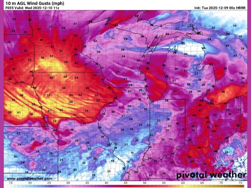
Winds are expected to gust between 50 and 70 mph, according to forecast data from Pivotal Weather, with the strongest gusts likely across northern Iowa and southern Minnesota. This wind event, paired with snow already on the ground, could trigger ground blizzard conditions — creating whiteouts, drifting snow, and near-zero visibility even in areas without new snowfall.
High Winds Could Create Ground Blizzard and Travel Disruptions
Forecasters warn that the combination of strong winds and existing snow cover will likely turn open rural areas into blinding snow zones, especially along highways and exposed farmlands. Even a small layer of snow on the surface can be lifted and blown around by such powerful gusts, producing the same travel dangers as an active snowstorm.
“People often underestimate these setups because no new snow is falling,” one meteorologist explained. “But with winds like this and snow already on the ground, conditions can deteriorate in minutes.”
The latest HRRR model run shows widespread wind gusts exceeding 60 mph across eastern South Dakota, western Iowa, and southern Minnesota, extending eastward into Illinois throughout the day Wednesday. These winds are strong enough to knock down tree branches, damage power lines, and cause localized power outages in rural and suburban areas.
Hazardous Conditions Expected on Roads
Officials are urging drivers across the Midwest to avoid unnecessary travel, particularly during the late-morning and afternoon hours when gusts are forecast to peak. Visibility could drop to less than a quarter-mile in many areas, making road travel extremely dangerous.
Even experienced winter drivers are being told to prepare for rapidly changing visibility and slick roadways due to drifting snow. Truckers and high-profile vehicles are especially at risk, as strong crosswinds could lead to vehicle rollovers on major interstates such as I-35, I-80, and I-90.
Widespread Impact and Preparedness
- Wind gusts: 50–70 mph across Minnesota, Iowa, South Dakota, and Illinois
- Main hazards: Whiteouts, blowing snow, hazardous travel, and power outages
- Timing: Early Wednesday morning through late evening
- Advisory level: High wind warnings and winter weather advisories likely to be issued
Authorities recommend securing outdoor items, checking travel advisories before leaving home, and preparing emergency kits in case of power disruptions or stranded vehicles.
This weather setup underscores how fast winter conditions can shift across the Midwest — and how even “no new snow” days can turn perilous.
Stay tuned to NapervilleLocal.com for live weather alerts and regional updates as Minnesota, Iowa, South Dakota, and Illinois face one of the most dangerous wind events of the season.

I’ve lived in Naperville long enough to see how quickly our community changes — from new developments downtown to sudden shifts in our Midwest weather. Reporting on Naperville news and daily forecasts gives me the chance to keep neighbors informed about what really matters. My goal is simple: deliver clear, timely updates so you always know what’s happening in our city and what to expect from the skies above.