
Mississippi, Alabama, Georgia, and Florida Face Renewed Winter Cold With Teens and 20s Possible by January 16
SOUTHEASTERN UNITED STATES — After a brief stretch of milder conditions, winter is not finished, and another push of colder air is expected to spread across the Southeast next week following multiple cold fronts and periods of rain. Forecast signals shown in the latest data indicate that a renewed surge of cold air will arrive after next week’s frontal system, bringing significantly colder overnight temperatures to much of the region by Friday, January 16.
Another Cold Push Expected After Rain and Cold Fronts
The forecast discussion highlights that a series of cold fronts and rain events will move through the Southeast first. Once those systems clear, another, stronger push of colder air looks increasingly likely. While exact temperature values may still shift, meteorologists note that the overall signal for colder weather is strong, suggesting this is not a brief dip but a meaningful return of winter conditions.
Teens Possible in the Interior Southeast, 20s Along the Gulf Coast
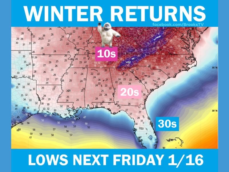
The temperature map included in the data shows:
- Overnight lows in the teens across parts of the interior Southeast
- 20s across much of Alabama, Georgia, and Mississippi
- 30s extending into Florida, especially inland areas
These values represent overnight lows, meaning early mornings could feel sharply colder than recent days.
Mississippi and Gulf States Face Renewed Cold Risk
Mississippi is clearly included within the colder air mass shown, with widespread 20s expected overnight in many areas. This marks a notable shift after recent milder nights and raises concerns for:
- Cold-sensitive plants
- Outdoor plumbing
- Livestock and agriculture
Even without snow or ice, sustained cold nights can cause impacts, particularly in regions less accustomed to extended cold spells.
Florida Returns to Jacket Weather
Florida is also expected to feel the effects of the colder pattern. Forecast guidance suggests:
- 20s possible along parts of the I-10 corridor
- 40s at night in South Florida
- Afternoon highs mainly in the 50s and 60s statewide
This represents a clear end to the recent “fake spring” conditions referenced in the forecast discussion.
Why This Cold Matters
Meteorologists emphasize that this pattern reflects a broader shift, not an isolated cold morning. The Southeast appears positioned for another winter reminder, reinforcing that the season is not over despite recent warm days. While no snowfall or wintry precipitation is indicated in the current data, cold alone can still cause disruptions, especially during early morning hours.
What Residents Should Prepare For
As the colder air approaches, residents across the Southeast should:
- Monitor overnight temperature forecasts
- Protect cold-sensitive plants and outdoor pipes
- Prepare for colder morning commutes
The message from the data is clear: winter still has a say, and warmer weather has an expiration date. For continued weather updates and regional impact coverage, follow NapervilleLocal.com.

I’ve lived in Naperville long enough to see how quickly our community changes — from new developments downtown to sudden shifts in our Midwest weather. Reporting on Naperville news and daily forecasts gives me the chance to keep neighbors informed about what really matters. My goal is simple: deliver clear, timely updates so you always know what’s happening in our city and what to expect from the skies above.