
Mississippi Storm Alert: Squall Line Could Bring 60 MPH Winds and Possible Spin-Up Tornadoes to Pine Belt Wednesday Evening
MISSISSIPPI — Another round of strong to severe thunderstorms is expected to move across Mississippi late Wednesday, as a developing squall line pushes through the state and targets communities across the Pine Belt region during the evening hours.
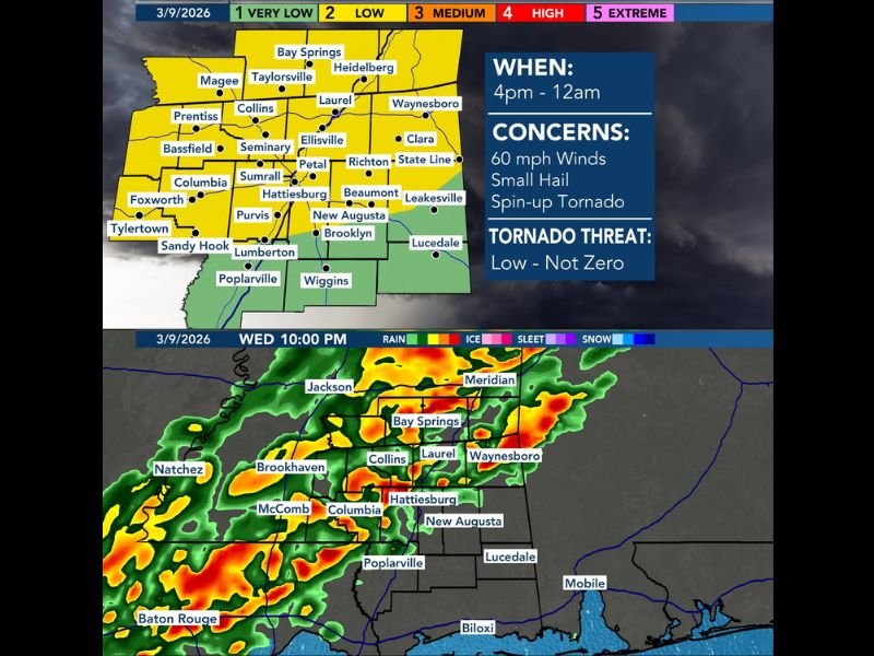
Forecasters say the storms are expected to reach parts of southern Mississippi between roughly 4 PM and midnight, bringing the potential for damaging wind gusts around 60 miles per hour, pockets of small hail, and the possibility of a brief tornado. While the overall tornado risk remains low, meteorologists stress that it is not zero, particularly if rotating storm segments develop within the advancing line of storms.
Squall Line Expected to Sweep Across Southern Mississippi
Forecast models show a line of storms forming west of the region before advancing eastward across Mississippi during the late afternoon and evening.
The strongest storms are expected to move through communities including:
- Hattiesburg
- Laurel
- Collins
- Petal
- Richton
- Sumrall
- Ellisville
- Waynesboro
- Bay Springs
- Columbia
- Poplarville
- Purvis
- Brooklyn
- New Augusta
- Lumberton
- Leakesville
- Lucedale
These areas sit within the Pine Belt region, where the squall line could bring the most active weather during the evening timeframe.
Damaging Winds the Primary Concern
The main hazard associated with the approaching storm line will be damaging straight-line winds, which could reach or exceed 60 mph in the strongest storms.
Wind gusts of this strength can:
- Down tree limbs or entire trees
- Damage roofs and siding
- Cause localized power outages
- Create hazardous travel conditions
Because the storms will likely form into a long line of thunderstorms, damaging wind gusts could affect multiple communities as the system moves eastward.
Small Hail and Brief Tornado Possible
In addition to wind damage, forecasters say storms may also produce small hail, especially within stronger storm cells embedded in the line.
There is also a low but notable chance of a brief spin-up tornado, which can sometimes occur within fast-moving squall lines when small areas of rotation develop along the storm boundary. These quick tornadoes can form rapidly and often occur with little warning.
Storms Likely During Evening Hours
Forecast timing currently suggests the most active weather will occur between late afternoon and late evening, with storms gradually moving east across Mississippi.
Radar projections indicate the storm line may approach areas such as Brookhaven, McComb, Columbia, and Hattiesburg before continuing east toward Laurel and Waynesboro during the evening hours. Residents across southern Mississippi are encouraged to monitor updated forecasts and weather alerts Wednesday afternoon and evening, as conditions may change as the storm line approaches.

I’ve lived in Naperville long enough to see how quickly our community changes — from new developments downtown to sudden shifts in our Midwest weather. Reporting on Naperville news and daily forecasts gives me the chance to keep neighbors informed about what really matters. My goal is simple: deliver clear, timely updates so you always know what’s happening in our city and what to expect from the skies above.