
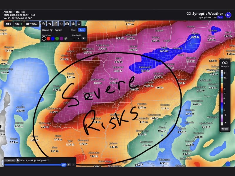
Missouri, Illinois, Indiana, Kentucky and Ohio Face Heavy Rain and Severe Weather Pattern Late March Into April With Repeated Storm Rounds Possible
UNITED STATES — A more active and potentially impactful weather pattern is beginning to take shape across the central United States, with forecasters highlighting an increasing risk of both heavy rainfall and severe storms as March transitions into April.
The setup suggests that this will not be a one-day event, but rather a prolonged pattern where multiple storm systems move across the same regions over time, raising concerns for both severe weather and accumulating rainfall totals.
Active Pattern Expected to Strengthen Into April
Forecast signals indicate that the overall weather pattern will ramp up as the month progresses, particularly across the central Plains and Midwest. This shift is being driven by a more dynamic jet stream pattern, which can support repeated storm development.
When patterns like this become established, they often lead to several consecutive days of unsettled weather, rather than isolated storm events. This means communities could see multiple rounds of storms over a period of days or even weeks.
Core Risk Zone Centers on Midwest and Lower Ohio Valley
The highlighted region of concern includes Missouri, Illinois, Indiana, Kentucky, and Ohio, where the combination of moisture, instability, and storm tracks could align to produce the greatest impacts.
Cities across this corridor may experience repeated rainfall events, with storms tracking along similar paths. This increases the likelihood of higher rainfall totals compared to areas outside the main storm corridor.
Heavy Rainfall Totals Could Build Over Time
Forecast projections suggest that rainfall totals could become significant, especially where storms repeatedly move across the same areas. While individual storms may not seem extreme on their own, the cumulative effect of multiple rounds can quickly add up.
This type of pattern is particularly concerning because it allows the ground to become saturated, reducing its ability to absorb additional rainfall and increasing the risk of runoff and localized flooding.
Severe Weather Risks Also Part of the Pattern
In addition to heavy rain, this setup also supports the potential for severe weather across the region. Thunderstorms forming within this pattern could bring strong winds, hail, and other severe impacts.
The combination of severe weather and heavy rainfall can create compounding hazards, especially if storms become organized or repeatedly impact the same locations.
Multiple Days of Storm Chances Ahead
One of the key concerns with this setup is the duration of the pattern. Rather than a single storm system moving through and clearing out, this pattern may bring several days of storm chances in the coming weeks.
This increases the importance of staying updated on forecasts, as conditions may evolve from day to day depending on how each system develops.
What Residents Should Expect
Residents across Missouri, Illinois, Indiana, Kentucky, and Ohio should prepare for a more active stretch of weather heading into April. This includes the possibility of repeated rainfall events, occasional severe storms, and changing conditions over multiple days. Planning ahead, staying weather-aware, and monitoring updates will be important as this pattern continues to evolve.
What Happens Next
Forecast models will continue to refine how this pattern develops, including which areas receive the heaviest rain and strongest storms.
While details will become clearer over time, the early signal points to a prolonged period of active weather across the central United States. Stay with NapervilleLocal.com for continued updates as this heavy rain and severe weather pattern develops into April.

I’ve lived in Naperville long enough to see how quickly our community changes — from new developments downtown to sudden shifts in our Midwest weather. Reporting on Naperville news and daily forecasts gives me the chance to keep neighbors informed about what really matters. My goal is simple: deliver clear, timely updates so you always know what’s happening in our city and what to expect from the skies above.