
Monday Feels Like Summer Is Back: Warm, Humid, and Mostly Dry With Isolated Afternoon Storms Possible Before More Organized Storms Arrive Tonight
LOCAL AREA — Summer has apparently not gotten the memo that it is only mid-April. Monday is rolling in warm, humid, and mostly cloudy — a carbon copy feel of Sunday — with temperatures climbing from the low 60s in the morning all the way to the upper 70s by evening. Most of the day will stay dry, but an isolated afternoon thunderstorm cannot be ruled out, and more organized storm activity is expected to work into the area later tonight.
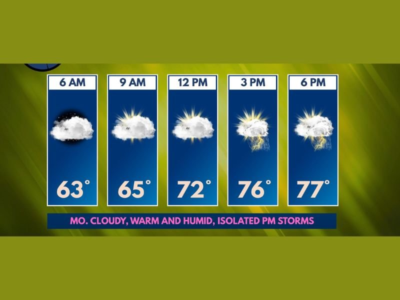
Warm and Humid All Day With Plenty of Cloud Cover
The day starts at a mild 63°F at 6 AM and barely budges through the morning, sitting at 65°F by 9 AM under mostly cloudy skies. From there, temperatures climb more steadily through the midday hours, reaching 72°F by noon before surging to 76°F at 3 PM and peaking near 77°F by 6 PM.
The humidity is noticeable today, giving the air a thick and heavy feel that reinforces just how summer-like this pattern has become for mid-April. Cloud cover will be a persistent feature throughout the day, keeping skies mostly cloudy from morning through evening despite the warm temperatures building underneath.
Most of the Day Stays Dry — But Watch the Afternoon
Despite the clouds and humidity, the vast majority of Monday is expected to remain dry for most residents. Forecasters anticipate that most, if not all, of the morning and early afternoon hours will pass without meaningful rainfall reaching the ground.
However, the combination of warmth, humidity, and afternoon instability could be enough to spark a few isolated to widely scattered thunderstorms during the peak heating hours around 3 PM. Any storm that does develop would not need much energy to produce hail and gusty winds, so residents should keep an eye on the sky through the afternoon even if the morning looks completely benign.
More Organized Storms Arrive Tonight
The more widespread and organized round of storm activity is expected to arrive later tonight as a more defined weather system works into the area. While severe weather does not appear to be a significant concern with the evening and overnight storms, the activity will be better organized and cover a broader area than any isolated afternoon cells.
Residents heading to bed Monday night should keep weather alerts active on their phones in case storms become more active than currently anticipated as they push through the area overnight. Stay with NapervilleLocal.com for the latest weather updates and local forecast coverage.

I’ve lived in Naperville long enough to see how quickly our community changes — from new developments downtown to sudden shifts in our Midwest weather. Reporting on Naperville news and daily forecasts gives me the chance to keep neighbors informed about what really matters. My goal is simple: deliver clear, timely updates so you always know what’s happening in our city and what to expect from the skies above.