
Monday: Minneapolis Is Ground Zero for the Worst Weather in America Today as a Level 3 of 5 Severe Weather Outbreak Threatens Minnesota, Wisconsin, and the Upper Midwest
MINNEAPOLIS, Minn. — The worst weather in the entire United States today is zeroing in on the Minneapolis metro area and the broader Upper Midwest, with a significant and well-defined severe weather outbreak placing the Twin Cities at the bull’s-eye of a Level 3 of 5 risk on the Storm Prediction Center’s Day 1 outlook.
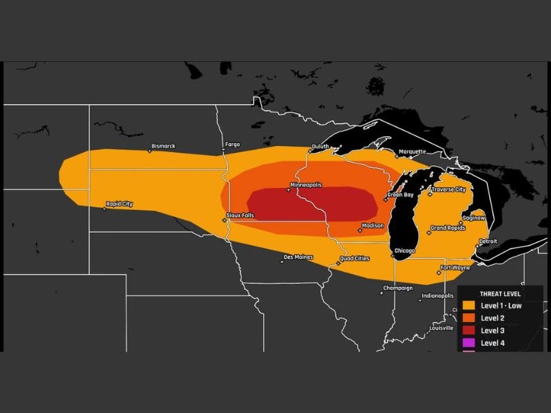
The threat stretches in a broad corridor from the Dakotas through Minnesota, Wisconsin, and into the northern Great Lakes region, with the most dangerous conditions concentrated directly over and around Minneapolis.
Level 3 Risk Centered Directly Over Minneapolis
The dark red Level 3 severe weather zone on today’s outlook map is unmistakably focused on Minneapolis and the surrounding region, making it the single most dangerous place to be in the United States for severe weather today. A Level 3 enhanced risk on the SPC scale indicates a strong likelihood of numerous severe storms capable of producing significant hazards across the highlighted area.
Communities including Sioux Falls, Madison, and Green Bay fall within or very close to the Level 3 zone as well, while the broader Level 2 risk extends outward to cover Fargo, Duluth, Traverse City, Saginaw, Grand Rapids, and Chicago in an expansive orange ring surrounding the core threat area.
Enormous Geographic Footprint Stretches From the Dakotas to the Great Lakes
The overall severe weather footprint today is massive, covering a sweeping corridor that runs from Rapid City and Bismarck in the west all the way through the Twin Cities and eastward into the northern Great Lakes region. The Level 1 low risk zone extends even further, reaching southward through Des Moines, Quad Cities, Champaign, Fort Wayne, and Indianapolis before tapering off toward Louisville and Bowling Green.
This means that while Minneapolis carries the greatest danger, a very large portion of the Upper Midwest and northern plains are under at least some level of severe weather threat today — from the wide open prairies of the Dakotas all the way to the shores of Lake Michigan and Lake Huron.
What Communities Need to Know Right Now
For residents in and around Minneapolis, Sioux Falls, Madison, and Green Bay — the Level 3 core — today is a day to take the threat with full seriousness. Severe storms in a Level 3 setup are capable of producing large and damaging hail, destructive wind gusts, and tornadoes, and the risk is not isolated to a single afternoon window but could persist through much of the day and evening.
Residents further out in the Level 2 zone — including Fargo, Duluth, Chicago, Grand Rapids, and Traverse City — face a meaningful but somewhat lower tier of severe weather risk and should also remain weather aware and prepared throughout the day.
Everyone in the outlined risk areas should have severe weather alerts active on their devices, know their nearest shelter location, and monitor updated forecasts closely as the outbreak develops through the day. Stay with NapervilleLocal.com for the latest weather updates and local forecast coverage.

I’ve lived in Naperville long enough to see how quickly our community changes — from new developments downtown to sudden shifts in our Midwest weather. Reporting on Naperville news and daily forecasts gives me the chance to keep neighbors informed about what really matters. My goal is simple: deliver clear, timely updates so you always know what’s happening in our city and what to expect from the skies above.