
Multi-State Tornado Threat Expands From Great Lakes to Gulf Coast With Nashville, Memphis, Indianapolis and Atlanta in High-Risk Zone
NASHVILLE, TENNESSEE — A dangerous multi-state severe weather outbreak is expected to unfold from the Great Lakes to the Gulf Coast as meteorologists warn of a growing tornado threat and widespread damaging winds across a broad region of the United States.
Forecast models show a large squall line of storms developing and sweeping eastward, bringing the potential for tornadoes, destructive wind gusts exceeding 75 mph, and large hail across parts of the Midwest and the Southeast.
Cities such as Nashville, Memphis, Huntsville, Indianapolis, Atlanta, and Knoxville sit within areas facing elevated storm risks as the system develops.
Wide Tornado Risk Stretching Across Multiple States
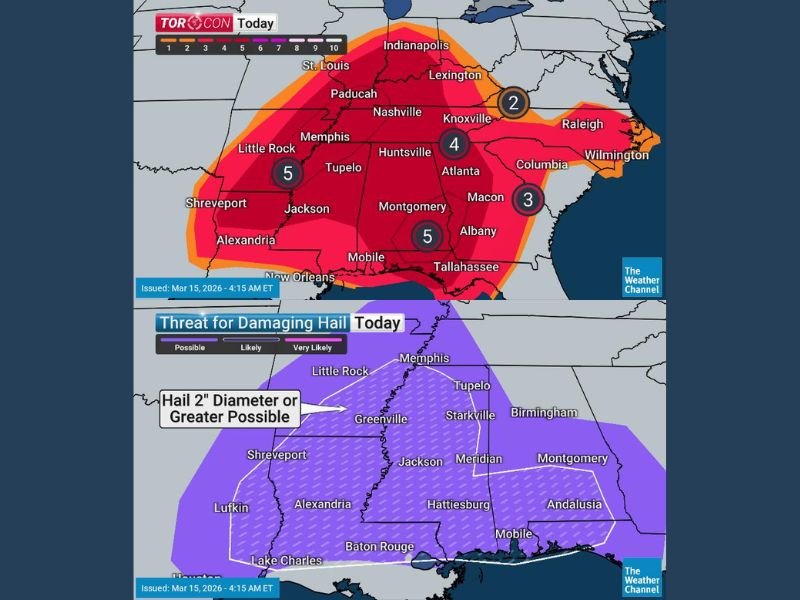
Weather analysts say the tornado threat Sunday will stretch across a wide corridor of states.
The highest risk areas include parts of:
- Tennessee
- Mississippi
- Alabama
- Kentucky
- Indiana
- Georgia
Storm risk maps show intense activity stretching from Little Rock and Memphis through Nashville and toward Indianapolis and Lexington, indicating a strong storm corridor developing across the central United States.
Meteorologists warn that many of the storms could occur after dark, which significantly increases the danger because people may be asleep when warnings are issued.
Damaging Winds Could Exceed 75 MPH
Even in areas where tornadoes do not develop, the storms could produce extremely strong straight-line winds. Forecast projections show wind gusts over 75 mph possible across areas including Memphis, Nashville, and Paducah, with strong winds also extending north toward Indianapolis.
These winds can cause widespread impacts such as:
- Downed trees
- Power outages
- Roof and structural damage
- Hazardous driving conditions
Officials say the large squall line could sweep quickly through communities, leaving little time for preparation once warnings are issued.
Large Hail Possible in Lower Mississippi River Valley
Another major concern is large hail, particularly across the Lower Mississippi River Valley.
Forecast maps indicate hail two inches in diameter or larger may develop in areas near Jackson, Tupelo, Greenville, and Meridian.
Hail of this size can damage vehicles, roofs, and crops while also posing safety risks to anyone caught outdoors during the storm.
Monday Tornado Risk Shifts Toward the Carolinas and Mid-Atlantic
While Sunday’s storms focus on the Midwest and Southeast, the severe weather threat is expected to shift east on Monday.
Forecasters say a TORCON rating of 7 — considered a high-end tornado risk on a scale of 1 to 10 — is forecast for parts of:
- Virginia
- North Carolina
- South Carolina
A broader tornado risk zone stretching from Pennsylvania southward to Florida may also see storms capable of producing tornadoes. Cities including Charlotte, Raleigh, Columbia, Charleston, and Savannah could face dangerous weather as the system tracks toward the Atlantic Coast.
Dangerous Timing as Storms Continue Overnight
One of the biggest concerns is the timing of the severe weather.
Many of the storms are expected to occur overnight or during evening hours, when visibility is lower and people are less likely to receive warnings quickly. Meteorologists emphasize that residents should prepare in advance and have multiple ways to receive emergency alerts.
Officials Urge Residents to Prepare
Emergency officials recommend that residents across the affected states take safety precautions before storms arrive.
Important safety steps include:
- Identifying a safe shelter location inside a sturdy building
- Monitoring weather alerts and warnings
- Avoiding travel during the peak of severe weather
Officials stress that storms capable of producing tornadoes, destructive winds, and large hail can develop quickly.
Storm System Will Continue Moving East
The severe weather outbreak is expected to evolve over the next two days as the storm system pushes eastward across the country.
Communities across the Midwest, Southeast, and eventually the Carolinas and Mid-Atlantic should stay alert for rapidly changing weather conditions. Meteorologists will continue monitoring the storm system as it develops and moves across multiple states. This report follows the editorial and formatting guidelines used for NapervilleLocal.com weather coverage .

I’ve lived in Naperville long enough to see how quickly our community changes — from new developments downtown to sudden shifts in our Midwest weather. Reporting on Naperville news and daily forecasts gives me the chance to keep neighbors informed about what really matters. My goal is simple: deliver clear, timely updates so you always know what’s happening in our city and what to expect from the skies above.