
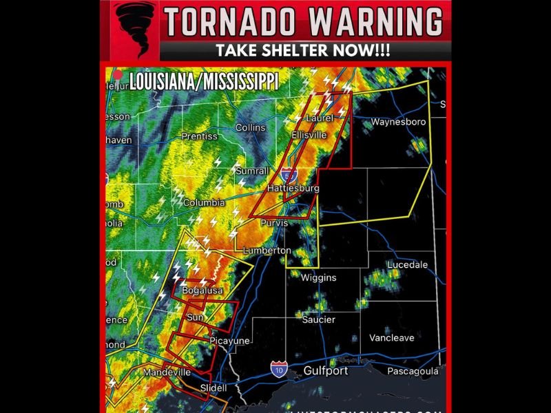
Multiple Tornadoes Reported Across Southern Mississippi and Southeast Louisiana as Dangerous Storm Line Moves Toward Hattiesburg, Laurel, and Bogalusa
HATTIESBURG, MISSISSIPPI — A dangerous line of severe thunderstorms capable of producing multiple tornadoes was moving across far southern Mississippi and southeast Louisiana, prompting urgent warnings for residents along the storm’s path.
Weather radar showed several tornado-warned storms embedded within a powerful squall line moving east at around 30 mph, placing several communities under immediate threat of severe weather.
Tornado Warnings Issued Across Mississippi and Louisiana
Meteorologists tracking the storm system issued multiple Tornado Warnings across parts of southern Mississippi and southeast Louisiana as the storm line intensified. Communities including Hattiesburg, Laurel, and Ellisville in Mississippi were in the path of the strongest storms as the system advanced eastward.
Radar signatures also indicated dangerous storm cells moving through areas near Bogalusa, Picayune, and Slidell in Louisiana. The warnings urge residents in affected areas to seek shelter immediately as tornadoes may already be occurring or could develop rapidly.
Intense Line of Storms Stretching Across the Region
Radar imagery shows a long line of powerful thunderstorms stretching from southeast Louisiana into southern Mississippi, producing frequent lightning, heavy rain, and intense wind.
Several individual cells embedded within the line appear to be rotating, increasing the risk for tornado development as the storms move eastward. Areas including Purvis, Lumberton, and Sumrall in Mississippi could also experience severe conditions as the storm line continues progressing through the region.
Storm Moving Toward Key Mississippi Communities
As the storms push east at roughly 30 mph, communities along the path should prepare for rapidly deteriorating weather conditions.
Cities such as Hattiesburg and Laurel sit directly along the projected track of the strongest storms, which could bring damaging winds, large hail, and tornadoes. Heavy rainfall and frequent lightning will also accompany the storms as they move across the region.
Residents Urged to Take Immediate Shelter
Emergency alerts stress that people in tornado warning areas should move to the lowest level of a sturdy building and stay away from windows. Mobile homes and vehicles offer little protection during tornadoes, and residents are encouraged to seek proper shelter immediately if warnings are issued.
Officials continue monitoring the storm system closely as it progresses across southern Mississippi and southeast Louisiana, where the tornado threat may persist into the evening hours.

I’ve lived in Naperville long enough to see how quickly our community changes — from new developments downtown to sudden shifts in our Midwest weather. Reporting on Naperville news and daily forecasts gives me the chance to keep neighbors informed about what really matters. My goal is simple: deliver clear, timely updates so you always know what’s happening in our city and what to expect from the skies above.