
Nearly 6 Inches of Rain Floods Grangeville, Louisiana — Streets Submerged as Residents Wake to Widespread Water Damage
GRANGEVILLE, LOUISIANA — Grangeville residents woke up Thursday to what looked more like a lake than a neighborhood after nearly 6 inches of rainfall inundated the small Louisiana community within a 24-hour span, turning roads into rivers and yards into ponds.
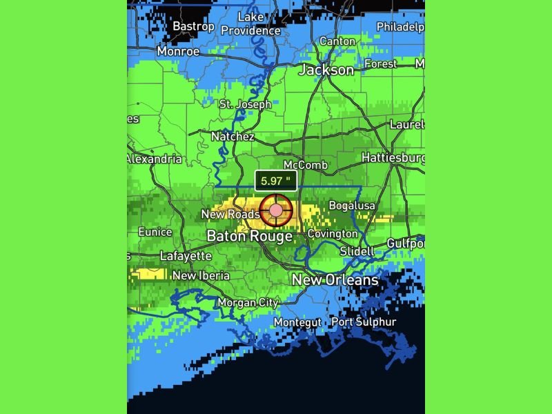
The deluge left parts of St. Helena Parish and surrounding areas waterlogged, with radar data showing 5.97 inches of rain falling just north of Baton Rouge. The rainfall, which hit quickly and with intensity, overwhelmed local drainage systems and caused several streets to become impassable due to standing water.
Heavy Rainfall Submerges Roads and Yards
According to WeatherBell Analytics, the heaviest rainbands parked over southern Louisiana late Wednesday into early Thursday morning, leading to rapid water accumulation across low-lying neighborhoods.
Grangeville, which typically sees gradual seasonal rainfall, received an entire month’s worth of precipitation in a single day, leaving some residents stranded or forced to navigate floodwaters by truck or boat.
“People woke up asking if they’d accidentally moved overnight into a Bass Pro Shop aquarium,” one local joked online, referencing the severe flooding that engulfed front yards, driveways, and ditches.
Nearby Baton Rouge saw lighter totals but wasn’t spared from the effects, as rising runoff pushed water toward city limits. Local officials urged drivers to avoid flooded streets and reminded residents to “Turn Around, Don’t Drown.”
Local Impacts and Safety Concerns
The National Weather Service has not yet issued an official flood warning for Grangeville but is monitoring additional rainfall potential through Friday. Forecasters say ditches and drainage canals remain full, and even moderate showers could quickly worsen flooding.
Residents reported that local roads were “slicker than ever,” with runoff causing vehicles to hydroplane and multiple rural roads to close temporarily. Photos shared on social media showed residents wading through knee-deep water, while others used makeshift wooden pallets or plastic crates to access vehicles.
“This wasn’t just a drizzle—it was like the sky forgot to turn off the faucet,” said one homeowner. “We had water lapping at our porch before sunrise.”
Baton Rouge Officials Monitoring Nearby Flood Risk
While Baton Rouge did not experience the same level of rainfall intensity, city officials said runoff from northern parishes could increase water levels in the coming days. Emergency management teams are watching creeks and bayous near Livingston and East Feliciana Parishes for any signs of additional overflow.
Meteorologists warned that another round of light rain is possible by late Friday, though it’s not expected to match the intensity of the midweek downpour.
What’s Next for South Louisiana
The extreme rainfall was part of a slow-moving moisture plume stretching from the Gulf of Mexico northward. This pattern has been responsible for recent flooding episodes across southern Mississippi and coastal Louisiana, with the heaviest impacts concentrated in the Baton Rouge–Grangeville corridor.
Forecasters expect gradual clearing by Saturday as the front pushes eastward, allowing floodwaters to slowly recede. However, officials say saturated soil could still cause standing water and drainage delays throughout the weekend.
Residents are urged to avoid unnecessary travel, check local road closure updates, and keep emergency supplies ready should another round of storms develop.
Stay tuned to NapervilleLocal.com for continuing coverage of Louisiana’s severe weather and community recovery updates.

I’ve lived in Naperville long enough to see how quickly our community changes — from new developments downtown to sudden shifts in our Midwest weather. Reporting on Naperville news and daily forecasts gives me the chance to keep neighbors informed about what really matters. My goal is simple: deliver clear, timely updates so you always know what’s happening in our city and what to expect from the skies above.