
Nebraska, Kansas, Missouri, Illinois, Indiana, Ohio Could See Multi-State Storm System April 2 With Snow West, Ice Transition, and Severe Storms East
UNITED STATES — A potentially significant early April storm system is showing up in long-range European model guidance, hinting at a multi-state impact stretching from the Central Plains into the Midwest and Ohio Valley around April 2.
While still several days out and subject to change, the setup suggests a classic spring storm with multiple weather hazards, including snow, ice, and thunderstorms across different regions.
Developing Storm Pattern Across the Central U.S.
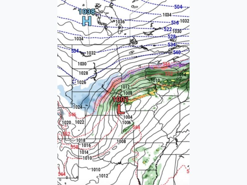
Forecast models indicate a strengthening low-pressure system forming over the central United States, with a projected pressure near 1001 mb, signaling a fairly organized storm.
The setup shows:
- A strong low-pressure center developing near Kansas/Missouri
- Cold air wrapping into the system from the northwest
- Warm, moisture-rich air surging northward ahead of the storm
This combination is typically associated with dynamic spring storms capable of producing multiple weather types at once.
Snow Expected in Western Nebraska and Nearby Areas
On the colder side of the system, western Nebraska and parts of the High Plains could see accumulating snow.
Key points include:
- Snow developing as colder air wraps around the storm
- Potential for late-season snowfall in western Nebraska
- Travel impacts possible depending on storm strength and track
This would be notable for early April, though not unheard of for the region.
Narrow Ice Transition Zone Possible
Between the snow zone and the warmer rain area, models show a tight transition band where freezing rain or sleet could occur.
This zone may impact parts of:
- Eastern Nebraska
- Northern Kansas
- Portions of Missouri and possibly Iowa
Even a narrow band of ice can create dangerous travel conditions, especially if surface temperatures hover near freezing.
Severe Storm Risk Expands Eastward
On the warm side of the system, conditions look favorable for rain and thunderstorms, with some storms potentially becoming severe.
Areas at risk include:
- Missouri
- Illinois
- Indiana
- Ohio
Possible threats include:
- Strong to damaging wind gusts
- Large hail
- Locally heavy rainfall
The exact severity will depend on how much instability and moisture return ahead of the system.
A Pattern Worth Watching
Meteorologists are also noting that this system may fit into a repeating late-month storm pattern, with similar setups occurring near the end or beginning of recent months.
While the idea of a “30-day cycle” remains debated, the trend of frequent storm systems during seasonal transitions is well established.
What This Means Going Forward
Although this storm is still several days away, early signals suggest:
- A multi-hazard event across multiple states
- Snow in the west, ice in the transition zone, and storms in the east
- Potential travel and weather impacts across a large portion of the central and eastern U.S.
Residents across the Plains, Midwest, and Ohio Valley should monitor updates closely over the coming days, as forecast details—including storm track and intensity—will become clearer. Stay with NapervilleLocal.com for continued coverage as this early April storm system develops.

I’ve lived in Naperville long enough to see how quickly our community changes — from new developments downtown to sudden shifts in our Midwest weather. Reporting on Naperville news and daily forecasts gives me the chance to keep neighbors informed about what really matters. My goal is simple: deliver clear, timely updates so you always know what’s happening in our city and what to expect from the skies above.