
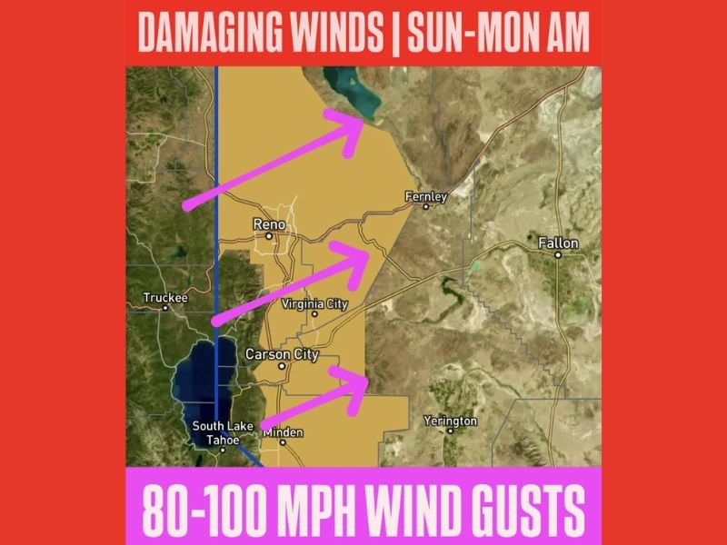
Nevada Braces for Dangerous Wind Event as 80–100 MPH Gusts Threaten Reno, Sparks, and Carson City From Sunday Into Monday
Nevada — A significant damaging wind event is forecast to impact western Nevada from Sunday into Monday morning, with meteorologists warning of 80 mph wind gusts across the Reno–Sparks metro area and 100 mph gusts along the ridgetops. Officials say widespread power outages are likely as the storm system intensifies, prompting a High Wind Warning for communities stretching from Reno and Carson City to Virginia City and Minden.
High Wind Warning Issued for the Region
The High Wind Warning highlights the potential for widespread damage, particularly in densely populated stretches of western Nevada. Forecasters expect:
- 80 mph wind gusts along major travel routes including US-395 and I-580
- 100 mph gusts at higher elevations and exposed ridgelines
- Downed trees, damaged power lines, and dangerous debris
- Travel difficulties for high-profile vehicles such as trucks and RVs
Officials say the timing of the strongest winds — late Sunday through early Monday — could worsen overnight impacts, especially if power outages occur in cold conditions.
Major Travel and Safety Concerns for Residents
The threat of rapid, high-velocity wind gusts may severely affect travel across the region. Drivers on mountain passes and open highway sections are warned to expect sudden crosswinds capable of pushing vehicles off course. The Reno–Carson City corridor, which includes several busy commuter routes, is especially vulnerable.
Power companies are preparing for the possibility of extended outages, as past storms with similar wind speeds have caused widespread disruption. Residents are urged to secure outdoor items, charge devices in advance, and avoid unnecessary travel during the peak of the event.
Communities Urged to Prepare Ahead of the Wind Event
Meteorologists emphasize that wind events of this magnitude can produce damage comparable to severe thunderstorms, even without rain or snowfall. The combination of strong, prolonged gusts and dry ground conditions raises the risk of falling branches and structural impacts.
Emergency management agencies recommend that residents:
- Stay informed through local alerts
- Prepare emergency kits with warm clothing, lights, and batteries
- Keep vehicles fueled in case of extended power loss
- Avoid wooded areas or unstable structures during peak winds
With gusts potentially exceeding 100 mph, experts describe this system as one of the stronger December wind events in recent years for western Nevada. For ongoing updates on severe weather conditions, travel impacts, and regional safety alerts, visit NapervilleLocal.com for continuous coverage.

I’ve lived in Naperville long enough to see how quickly our community changes — from new developments downtown to sudden shifts in our Midwest weather. Reporting on Naperville news and daily forecasts gives me the chance to keep neighbors informed about what really matters. My goal is simple: deliver clear, timely updates so you always know what’s happening in our city and what to expect from the skies above.