
New England Storm Defies Forecast With Longer-Lasting Snow Before Sudden Warm Surge, But Winter Set to Roar Back Next Weekend
NEW ENGLAND — What was expected to be a quick transition from snow to rain and freezing rain across southern and central New England didn’t unfold quite as forecast. Instead, colder air held firm longer than anticipated, allowing snow to continue falling even as warmer air pushed in above the surface.
Forecasters had anticipated a faster changeover, but the atmosphere proved more complex.
Snow Held On Longer Than Expected
The storm setup initially called for snow in southern and central New England before transitioning fairly quickly to rain or freezing rain. However, colder air remained entrenched at key elevations in the atmosphere, keeping precipitation falling as snow longer than projected.
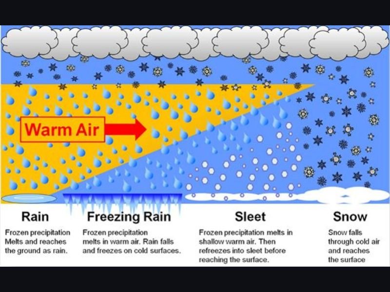
This type of scenario highlights how weather systems are not simply surface-based. The atmosphere operates in layers, and subtle differences in temperature at varying heights can dramatically alter precipitation type.
In several areas, radar imagery appeared to show snow, but trained spotters reported freezing rain and sleet developing in narrow bands — something that models did not fully capture.
Why the Forecast Shifted
Meteorologists rely heavily on temperature profiles and model guidance, but weather remains an evolving science. In this case, warm air aloft did not inject into the storm system as quickly or as uniformly as expected.
Because radar primarily provides a top-down view at certain elevations, it cannot always clearly reveal what is happening within the full vertical column of air. That’s why real-time surface observations and trained spotter reports remain critical during winter storms.
The event serves as a reminder that forecasting is a best educated projection — not a guarantee — especially during complex precipitation setups involving snow, sleet, freezing rain, and rain transitions.
A Brief Taste of Spring Next Week
Attention now shifts to a dramatic temperature swing expected next week. Warmer air will surge northward, bringing above-average temperatures across much of New England.
By Wednesday the 11th, some areas of southern and central New England could see highs climbing into the upper 60s to low 70s, even reaching into parts of northern New Hampshire and Vermont. That kind of warmth would represent a sharp contrast to recent winter conditions.
However, the warmth may not extend as strongly into northern Maine, where temperatures are still expected to remain much colder.
Winter Returns by the Weekend
The warm spell is expected to peak midweek before colder air quickly reasserts itself. By Saturday and Sunday, highs across much of the region could fall back into the teens and 20s, signaling that winter is far from over.
The back-and-forth pattern underscores how volatile early March weather can be in New England, where springlike warmth and winter cold can trade places within days.
Residents should prepare for rapid temperature swings and stay updated as forecast details refine. For continued national weather coverage and evolving outlooks, follow NapervilleLocal.com.

I’ve lived in Naperville long enough to see how quickly our community changes — from new developments downtown to sudden shifts in our Midwest weather. Reporting on Naperville news and daily forecasts gives me the chance to keep neighbors informed about what really matters. My goal is simple: deliver clear, timely updates so you always know what’s happening in our city and what to expect from the skies above.