
New Hampshire and Massachusetts Snow Trough Stalls Near Manchester–Nashua Corridor, Bringing 4–8 More Inches as Coastal Bands Add 2–6
NEW HAMPSHIRE — A stalled snow “trough” is intensifying snowfall across parts of New Hampshire and Massachusetts as moisture feeds in from two directions — a clipper system from the west and ocean moisture from the east — creating a narrow zone where snow is being “piled on” and totals are rising quickly into the afternoon.
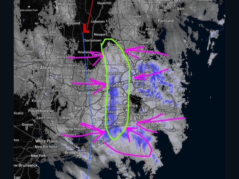
The Core Snow Zone: 4–8 More Inches Possible Into the Afternoon
The analysis shown highlights a green-circled corridor centered near the Manchester–Nashua area, extending into nearby parts of northern Massachusetts. In that zone, the forecast discussion indicates another 4–8 inches of snow could fall through the afternoon as the band remains locked in place.
This is the kind of setup where towns just a short drive apart can see drastically different totals, depending on whether the heavier band sits overhead for hours or shifts.
East and West of the Trough: Lower Totals but Still Accumulating
Outside the core zone, snowfall is expected to taper in intensity, but additional accumulation is still on the table.
Areas to the east, closer to the ocean and the onshore moisture feed, could see another 2–6 inches. Locations to the west of the trough axis are expected to see an additional 1–3 inches, reflecting how sharply snowfall drops off once you move away from the stalled band.
Why It’s Stalling: Nowhere for the Snow Band to Go
The update notes that the trough appears stalled, with the wind and pressure pattern essentially pinning the feature in place. The low pressure setup is pulling in cold air and moisture from both sides, helping sustain steady snow and forcing the focus of the heaviest snowfall down toward the ground and southward into southern New Hampshire and northern Massachusetts. When a trough stalls like this, the biggest impacts often come from duration — even moderate snow rates can add up fast if the band doesn’t move.
Cities and Travel Corridors Being Watched Closely
The radar and annotations place the most active snow band near heavily traveled corridors in southern New Hampshire and northeastern Massachusetts, including areas near Manchester, Nashua, Lowell, Worcester, Boston, Quincy, Brockton, Plymouth, Salem, and toward Providence. In practical terms, that means conditions can vary from “manageable” to “near-whiteout bursts” depending on exactly where the band is set up at any moment.
What to Expect Through the Afternoon
With the band continuing to feed from both west and east, snow can remain steady in the core corridor while nearby communities see lighter snow or intermittent breaks. This is not a uniform statewide storm — it’s a localized banded event where the totals depend on whether you sit under the trough for hours. Drivers should be ready for sudden changes in visibility and traction, especially on highways that cross the band’s axis.
Safety and Impact Notes for a Stalled Band Setup
Travel problems typically worsen in banded events because conditions can change quickly over a few miles. Plows may struggle to keep up in the core zone if rates stay steady.
If you must be on the roads, the most important step is slowing down before you hit the heavier snow band and allowing extra stopping distance. Visibility can drop rapidly when the steadier blue/purple returns on radar.
NapervilleLocal.com will continue monitoring major winter impacts across the U.S. and breaking down what the maps mean in plain terms for drivers and families.

I’ve lived in Naperville long enough to see how quickly our community changes — from new developments downtown to sudden shifts in our Midwest weather. Reporting on Naperville news and daily forecasts gives me the chance to keep neighbors informed about what really matters. My goal is simple: deliver clear, timely updates so you always know what’s happening in our city and what to expect from the skies above.