
New Hampshire, Massachusetts, Rhode Island, Connecticut and Maine Face Hit-or-Miss Snow Bands as Brief Bursts Push Some Spots Above 1–3 Inches
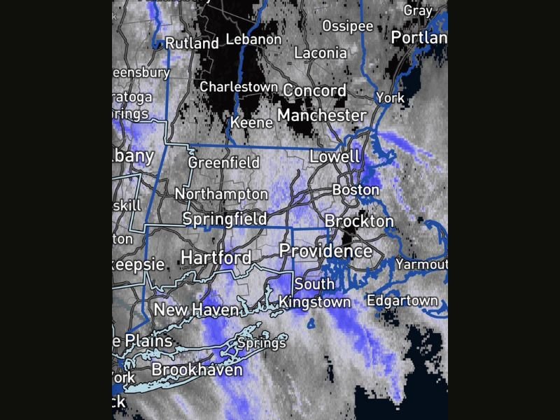
UNITED STATES — A banded, hit-or-miss snow event is playing out across parts of New Hampshire, Massachusetts, Rhode Island, Connecticut and Maine, with forecasters stressing this is not widespread snowfall. Instead, the radar pattern shows narrow, darker-blue “lumps” of steadier snow capable of producing quick accumulation in small areas, while locations just a few miles away may see light snow—or nothing at all.
Why This Snow Is “Hit or Miss”
The key detail in the forecast message is that snowfall depends heavily on where the heavier snow bands set up. These bands are localized and isolated, meaning totals can vary sharply over short distances. If a heavier band stalls overhead for even an hour or two, that one town can rack up more snow than surrounding communities.
Expected Snow Totals: “Average 1–3 Inches,” With Isolated Higher Amounts
The forecast message referenced an average of about 1–3 inches, emphasizing that some people expected much higher totals that were never part of the forecast. In this kind of setup, the average can stay modest while isolated pockets briefly exceed it under the strongest bands.
Timing: Snow Bands Continue Through the Afternoon
The update indicates the event continues through the afternoon, with no change to the original timing or amounts. In other words, this is a steady continuation of the same pattern: bursts of snow under the heavier bands, and far lighter impacts outside them.
Where the Snow Bands Were Showing Up
The radar image highlights snow in and around major corridors and cities across southern New England, including areas near:
- Boston and Brockton, Massachusetts
- Providence and South Kingstown, Rhode Island
- Hartford, Connecticut
- Manchester and Concord, New Hampshire
- Portland/Gray, Maine
Because the heavier “lumps” are narrow, the most meaningful impact is often not “statewide,” but neighborhood-by-neighborhood—especially along interstates and near the coast where banding can pivot and redevelop.
What This Means for Roads and the Evening Commute
Even if totals stay low overall, short-lived heavy bursts can still create real travel issues:
- Quick coatings that turn untreated roads slick
- Sudden visibility drops during steadier snow
- Refreezing and patchy black ice if temperatures hover near freezing
- High variability: one stretch of highway can be fine, the next can be snow-covered
Drivers should plan for rapid changes over a short drive—particularly from central Connecticut into Rhode Island and eastern Massachusetts, and from southern New Hampshire into coastal Maine.
Practical Safety Tips for a Banded Snow Setup
If you’re in the snow band zone:
- Slow down early when flakes intensify—roads can deteriorate in minutes
- Leave extra distance and avoid sudden braking
- Watch for bridges/ramps icing first
- Keep a scraper, gloves, and charger in the car in case conditions worsen fast
What to Watch Next
The biggest question isn’t “How much snow will New England get?”—it’s where the heavier bands will linger and which towns will end up with the higher local totals. If the darker-blue bands keep redeveloping over the same corridor, that’s where snow stacks up quickly. If they shift, the impact shifts with them. For more weather updates and plain-language breakdowns of fast-changing winter patterns, follow NapervilleLocal.com.

I’ve lived in Naperville long enough to see how quickly our community changes — from new developments downtown to sudden shifts in our Midwest weather. Reporting on Naperville news and daily forecasts gives me the chance to keep neighbors informed about what really matters. My goal is simple: deliver clear, timely updates so you always know what’s happening in our city and what to expect from the skies above.