
New Jersey and Eastern Pennsylvania Brace for a Long Sunday Snow Event as Rain-to-Snow Changeover Limits Totals
NEW JERSEY AND EASTERN PENNSYLVANIA — A prolonged Sunday snow event is expected to unfold across the region, beginning early in the morning and continuing on and off into the evening, with snow starting around 5 a.m. and lingering through roughly 7 p.m.
Forecasters say the system will begin as rain near the coast before transitioning to snow, a key factor that will hold down snowfall totals, especially in shoreline communities.
Timing: When Snow Starts and Ends
According to the latest forecast guidance, this will not be a quick-hitting burst of snow.
- Snow arrives around 5 a.m. Sunday
- Periods of snow continue through the daytime and into early evening
- Precipitation tapers off by early Sunday night
The long duration increases the chance for slick roads, even where totals remain modest.
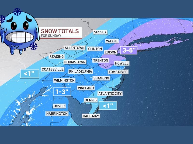
Snowfall Totals Vary Sharply by Location
Snow amounts will vary significantly depending on proximity to the coast and elevation.
Highest totals (3–5 inches) are expected across:
- Northern New Jersey
- Interior sections near Sussex County
- Areas farther inland where colder air holds longer
Moderate totals (1–3 inches) are likely for:
- Much of central and southern New Jersey
- Portions of eastern Pennsylvania, including areas near Philadelphia
Lower totals (less than 1 inch) are expected:
- Along the immediate coast
- Shore communities where rain mixes in early, reducing accumulation
Why Coastal Totals Will Be Lower
The biggest limiting factor for snow accumulation will be surface temperatures near the shoreline.
Snow is expected to:
- Start as rain at the shore
- Transition to snow later in the morning
- Melt on contact at times due to marginal temperatures
This changeover will significantly reduce total accumulation, even though snow may fall for several hours.
Travel and Impact Concerns
While this is not a major winter storm, impacts should not be overlooked.
- Morning and afternoon travel may be slick
- Bridges and untreated roads could become hazardous
- On-and-off snowfall may catch drivers off guard
Even lighter snow totals can create problems when spread out over many hours.
The Bottom Line
Sunday’s weather system will be more about duration than intensity, with rain changing to snow, modest accumulations, and localized higher totals inland. Coastal areas will see less snow, but interior New Jersey and eastern Pennsylvania should prepare for a wintry day.
For continued updates on snow timing, accumulation changes, and regional winter weather trends, stay connected with NapervilleLocal.com and check back frequently as forecasts are refined.

I’ve lived in Naperville long enough to see how quickly our community changes — from new developments downtown to sudden shifts in our Midwest weather. Reporting on Naperville news and daily forecasts gives me the chance to keep neighbors informed about what really matters. My goal is simple: deliver clear, timely updates so you always know what’s happening in our city and what to expect from the skies above.