
New Jersey and Pennsylvania Prepare for First Significant Snowfall as Updated Forecast Shows 3–6 Inches North of Trenton
New Jersey — Forecasters have released an updated first-call snowfall projection for New Jersey and southeastern Pennsylvania, showing a developing winter storm expected to bring a wide range of impacts from north to south. The latest guidance suggests that areas north of Trenton are likely to see 3 to 6 inches of snow, while regions farther south may experience sleet, freezing rain and lighter accumulations.
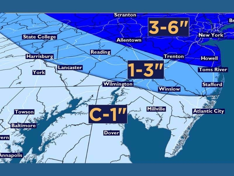
Heavier Snow Expected the Farther North You Go
Meteorologists emphasize that the key to this storm will be the placement of cold air. Forecast models consistently show that colder conditions remain locked in across northern New Jersey and parts of eastern Pennsylvania, allowing snow to dominate through much of the event.
Current projections indicate:
- 3–6 inches for areas including Scranton, Allentown, northern New Jersey and the New York metro region
- 1–3 inches for the transition zone stretching through Trenton, Reading, Lancaster and nearby communities
- Coating to 1 inch for southern New Jersey and portions of southeastern Pennsylvania
Forecasters stress that these numbers may shift slightly, but overall confidence remains high that the northern tier will see the greatest accumulation.
South of Trenton: Ice, Sleet and Freezing Rain Are the Main Concern
Forecasters note that the biggest hazard south of Trenton may not be snow at all, but ice formation. A shallow layer of warmer air aloft is expected to move over colder surface temperatures, creating conditions for sleet and freezing rain rather than widespread snowfall.
Experts say this area could see a glazing of ice, and potentially 0.10 to 0.15 inches in some locations. Even small amounts of freezing rain can cause slippery road conditions, especially on untreated surfaces. The outlook for extreme southern New Jersey suggests more of a mix-to-rain scenario, with accumulations likely topping out at a coating to one inch at most.
Some Forecast Models Show Higher Totals, But Experts Remain Cautious
While some computer models earlier hinted at 8 inches or more for portions of South Jersey and southeastern Pennsylvania, forecasters have dismissed those outputs as unlikely based on current trends.
Meteorologists emphasize that responsible forecasting requires comparing model data with atmospheric conditions, noting that warm layers aloft and mixing issues will cut into snow totals for southern zones. Forecast teams will continue to monitor the storm closely in the remaining 48 hours leading up to the event and will adjust snowfall lines north or south as necessary.
Travel Impacts Likely Through Saturday Morning
With snow expected to begin Friday night and linger into early Saturday, residents across New Jersey and Pennsylvania should prepare for slippery roads, reduced visibility and possible delays.
Northern regions, where snow remains the primary precipitation type, are likely to experience more widespread travel impacts. Meanwhile, areas south of Trenton should be alert to patchy ice, even where snowfall totals remain light. Officials encourage residents to follow real-time updates as meteorologists refine accumulation estimates and track potential shifts in the rain-snow line. For updated storm alerts, snowfall projections and winter travel guidance, visit NapervilleLocal.com.

I’ve lived in Naperville long enough to see how quickly our community changes — from new developments downtown to sudden shifts in our Midwest weather. Reporting on Naperville news and daily forecasts gives me the chance to keep neighbors informed about what really matters. My goal is simple: deliver clear, timely updates so you always know what’s happening in our city and what to expect from the skies above.