
New Jersey, New York, Connecticut, Rhode Island, Massachusetts, New Hampshire and Maine Could See Blizzard Conditions as Nor’easter Targets Northeast Sunday Into Monday
UNITED STATES — A powerful late-weekend winter storm is increasingly being flagged for the Northeast, with the potential for a high-impact nor’easter from Sunday into Monday. Forecast messaging tied to the latest outlook warns of heavy snowfall, the possibility of blizzard conditions, and near-zero visibility along the coast, especially in the corridor from New Jersey through coastal New England.
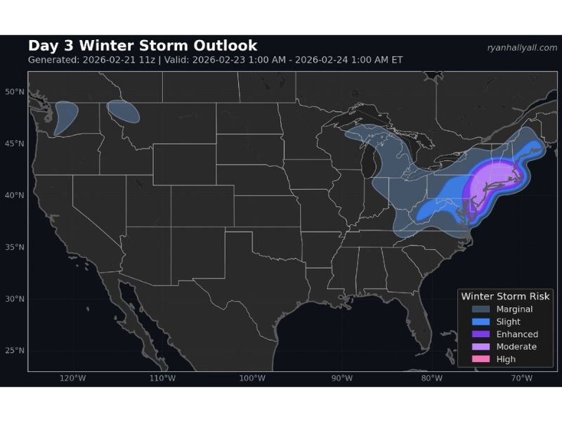
A Day 3 winter storm outlook valid from 1 a.m. Monday to 1 a.m. Tuesday (ET) shows the risk zone expanding and intensifying across the eastern seaboard. The highest threat level is focused nearest the coast, while inland areas fall into lower tiers where impacts may still be disruptive but could be more variable depending on the exact storm track.
Where the Highest Storm Risk Is Concentrated
The outlook highlights the most concerning impacts along the I-95 and coastal corridor, where a stronger, closer-tracking storm would produce heavier bands and stronger winds. The highest-risk shading is concentrated along and near the shoreline from New Jersey into parts of New York’s coastal region and onward through Connecticut, Rhode Island, and Massachusetts.
Farther north, higher-impact zones also extend into New Hampshire and Maine, indicating that the storm could remain organized and intense as it pushes deeper into New England. The map also shows lower-end winter storm risk stretching inland into parts of the Mid-Atlantic and interior Northeast, signaling that this is not a “coast-only” event even if the most extreme conditions ultimately focus near the shoreline.
Why This System Could Turn Dangerous Quickly
The biggest red flags mentioned in the update are snowfall rates and visibility. When a nor’easter strengthens offshore, it can wrap moisture back into the coastline while tightening the pressure gradient, resulting in stronger winds. That combination can create conditions where:
- Snow falls heavily enough that roads become snow-covered fast
- Wind drives blowing and drifting snow, lowering visibility to dangerous levels
- Travel becomes difficult or impossible for periods, especially along coastal highways
- Power interruptions become more likely if heavy, wet snow combines with wind
Even a modest shift in track can change who gets the worst of the snow bands. A storm that hugs the coast typically increases impacts for coastal communities, while a slightly offshore track can reduce totals inland but still bring significant wind and heavy precipitation near the shoreline.
What Residents Should Do Ahead of Sunday Night
With Sunday into Monday identified as the main impact window, residents across New Jersey, New York, Connecticut, Rhode Island, Massachusetts, New Hampshire, and Maine should be prepared for forecast adjustments and potentially rapid deterioration in travel conditions.
Practical steps include having essentials on hand, charging devices, checking vehicle readiness, and keeping travel plans flexible. The most important action is to monitor updates closely, because the difference between a moderate storm and a major one can come down to relatively small track changes.
For more weather coverage written in a clear, local-news style, visit NapervilleLocal.com.

I’ve lived in Naperville long enough to see how quickly our community changes — from new developments downtown to sudden shifts in our Midwest weather. Reporting on Naperville news and daily forecasts gives me the chance to keep neighbors informed about what really matters. My goal is simple: deliver clear, timely updates so you always know what’s happening in our city and what to expect from the skies above.