
New Jersey Shore Snow and Wind Threat Could Swing From Moderate to Major If Coastal Low Shifts Just 50 Miles Closer Monday
NEW JERSEY — A developing coastal storm could deliver dramatically different outcomes along the Jersey Shore versus inland communities, and forecasters are stressing that a shift of just 50 miles in the storm’s track could be the difference between a moderate event and a major coastal hit as the system peaks into Monday.
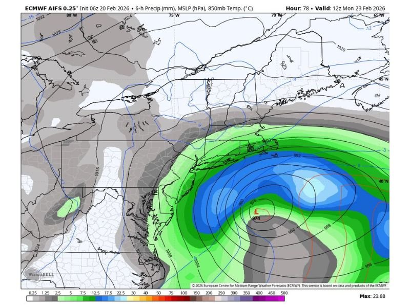
The latest model snapshot shows a strong low-pressure center positioned offshore, with tighter pressure lines wrapped around it and a broad precipitation field rotating toward the Mid-Atlantic and southern New England coastline. The core message is simple: the coast is far more sensitive to the storm’s exact position than inland areas, where “thinking hasn’t changed” in the latest commentary.
Why a 50-Mile Shift Matters So Much Along the Coast
For shoreline communities, small track changes can sharply increase impacts because they change where the storm’s strongest lift and moisture line up. If the low nudges closer to the coastline, the Jersey Shore can be placed under heavier bands and stronger winds for a longer stretch of time, raising the risk of rapid accumulation, whiteout bursts, and coastal travel disruptions.
If the storm stays farther offshore, the most intense precipitation and wind field remain more over water, and totals on land—especially inland—can be lower. That is why the “50-mile” detail is not exaggeration. In coastal storms, it is often the margin between a plowable snow and a headline-maker.
What the Map Suggests for New Jersey: Shore Versus Inland
Based on the guidance shown, the offshore storm is positioned to focus its strongest influence near the Atlantic side of the region. That keeps the Jersey Shore in the zone where impacts can escalate quickly if banding tightens, while inland areas may see steadier but less extreme conditions.
Even without locking in exact totals from this single frame, the forecast concern is clear: the coastal strip of New Jersey is the area most likely to be “hammered” if the track shifts closer. Inland towns could still see disruptive snow, but the signal suggests less volatility there compared to the shoreline.
What Residents Should Do While Forecasts Tighten Up
Because this is a track-sensitive setup, preparation should focus on readiness rather than one specific number. If you live or travel near the Jersey Shore, plan for the higher-impact scenario until the storm’s path becomes clearer.
Helpful steps include:
- Keep travel flexible for Sunday night into Monday
- Charge devices and check backup heat plans
- Stock essentials in case roads become difficult
- Monitor updates for changes in the storm’s coastal track
Forecast confidence will improve as the storm approaches and the track uncertainty narrows. For now, the key takeaway remains that coastal New Jersey is in the zone where a relatively small change in storm position can cause a big jump in impacts. For more weather updates written in a clear, practical format, visit NapervilleLocal.com for continued coverage.

I’ve lived in Naperville long enough to see how quickly our community changes — from new developments downtown to sudden shifts in our Midwest weather. Reporting on Naperville news and daily forecasts gives me the chance to keep neighbors informed about what really matters. My goal is simple: deliver clear, timely updates so you always know what’s happening in our city and what to expect from the skies above.