
New Year’s Eve Clipper to Bring Snow, Freezing Rain, and Hazardous Travel Across Illinois, Indiana, Michigan, and Ohio
INDIANA — A fast-moving New Year’s Eve clipper system is set to sweep through the region from Wednesday evening into early Thursday morning, bringing a mix of snow, freezing rain, and dangerous travel conditions across parts of Illinois, Indiana, Michigan, and Ohio. Forecast models highlight sharply varying impacts, with some areas facing light accumulations and others preparing for several inches of snow.
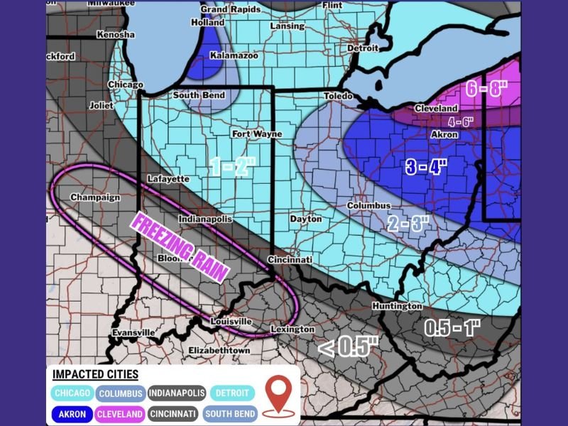
Snowfall Ranges Expected Across Multiple States
The clipper system is expected to intensify as it moves through the Midwest late Wednesday. According to the forecast map, Central Indiana, Northern Indiana, Southern Michigan, and Northern Ohio will be among the regions most impacted by accumulating snow.
Projected snowfall amounts include:
- 6–8 inches for areas near Cleveland
- 4–6 inches across Northeast Ohio
- 3–4 inches around Akron and surrounding zones
- 2–3 inches across parts of Central Ohio
- 1–2 inches for portions of Northern Indiana and Southern Michigan
- Less than 1 inch for areas farther south, including Kentucky and southern Indiana
These gradients show that the heaviest snow will stay concentrated in the eastern Great Lakes corridor, while lighter totals extend westward toward Illinois and Indiana.
Freezing Rain Zone Could Cause Dangerous Travel
One of the most concerning components of this system is the freezing rain corridor, highlighted along and west of I-74. Areas including Champaign, Bloomington, Indianapolis, and Louisville fall under the freezing-rain risk zone.
Forecasters warn that even minimal glaze accumulation could lead to slick roads, black ice, and hazardous driving conditions overnight into early Thursday morning. Combined with expected snowfall to the north, travel impacts may cover multiple states simultaneously.
Strong Winds Will Add to Hazards
Wind gusts up to 35 MPH are expected as the clipper passes through. These winds may cause:
- Blowing and drifting snow
- Rapidly reduced visibility
- Increased chances of icy patches forming
- Hazardous travel on open highways
Residents planning New Year’s Eve travel are urged to exercise caution, delay non-essential trips, and monitor updated conditions through the night.
Major Cities in the Impact Path
Several major urban areas will feel effects from this system, including:
Chicago, Columbus, Indianapolis, Detroit, Akron, Cleveland, Cincinnati, and South Bend.
While impacts differ by location, most areas will see some combination of snow, wind, and potential freezing precipitation.
Residents Urged to Prepare Ahead of the Storm
With the storm arriving during a high-travel holiday period, forecasters emphasize watching conditions carefully and preparing for rapid weather changes. Roads may deteriorate quickly Wednesday night, and early-morning commutes on Thursday could be affected across multiple states. Stay with NapervilleLocal.com for continuing updates as new forecast data becomes available.

I’ve lived in Naperville long enough to see how quickly our community changes — from new developments downtown to sudden shifts in our Midwest weather. Reporting on Naperville news and daily forecasts gives me the chance to keep neighbors informed about what really matters. My goal is simple: deliver clear, timely updates so you always know what’s happening in our city and what to expect from the skies above.