
New York, Vermont, New Hampshire, Maine Rain Showers Spread From Syracuse, Albany Into Bangor With Freezing Rain Risk North Overnight
ALBANY, NEW YORK — A broad area of rain is moving across the Northeast tonight, spreading from upstate New York into Vermont, New Hampshire, and Maine. While most areas will see steady rain, colder northern regions could experience pockets of freezing rain and light snow overnight.
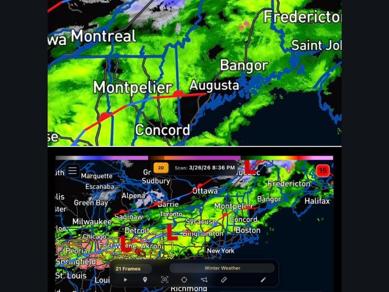
Rain Expands From Syracuse and Albany Into New England
Radar imagery shows widespread rain stretching from areas near Syracuse and Binghamton through Albany and into western New England. The system continues to push east toward cities such as Concord, Augusta, and Bangor. This steady precipitation is expected to continue overnight as the system moves deeper into the region.
Freezing Rain Risk Develops Across Northern Areas
Colder air farther north is creating the potential for freezing rain, especially across northern Vermont, northern New Hampshire, and interior Maine. These areas may see slick conditions develop as temperatures hover near or below freezing while precipitation continues.
Light Snow Also Possible in Higher Elevations
In addition to freezing rain, some light snow may mix in across higher elevations and northernmost communities. However, accumulation is expected to remain limited. Most of the region will remain warm enough for rain rather than snow.
System Continues Into Thursday Morning
The precipitation is expected to persist through the overnight hours and into Thursday morning before gradually tapering off. This timeline suggests a prolonged period of wet conditions for much of New England, especially during the early morning commute.
Secondary Showers Possible After Initial Wave
Following this system, another round of showers may move into the region, continuing unsettled weather into the next period. While not as widespread, it could keep conditions damp beyond the initial wave.
What Residents Should Expect
Residents from New York through Vermont, New Hampshire, and Maine should prepare for a steady period of rain overnight, with localized freezing rain risks in northern areas.
Travel conditions may become slippery in colder regions, especially where freezing rain develops. Stay with NapervilleLocal.com for continued updates, regional forecasts, and real-time alerts as this system moves across the Northeast.

I’ve lived in Naperville long enough to see how quickly our community changes — from new developments downtown to sudden shifts in our Midwest weather. Reporting on Naperville news and daily forecasts gives me the chance to keep neighbors informed about what really matters. My goal is simple: deliver clear, timely updates so you always know what’s happening in our city and what to expect from the skies above.