
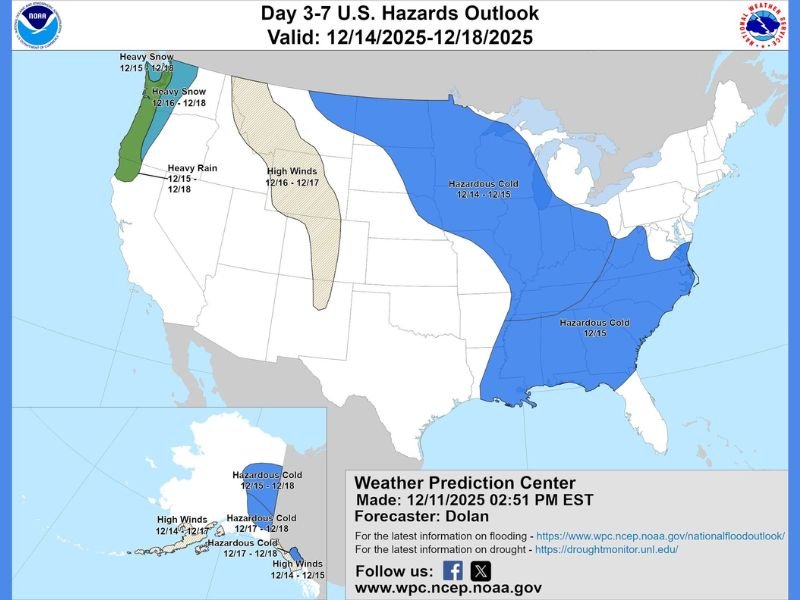
NOAA Hazards Outlook Warns of Hazardous Cold Across the Midwest, Great Lakes, Ohio Valley, and Southeast From December 14–18 as Strong Cold Front Pushes South
United States — A newly issued NOAA Day 3–7 U.S. Hazards Outlook shows a large portion of the nation preparing for hazardous cold as a strong Arctic front pushes southward between December 14 and December 18. Forecasters warn that this surge of cold air will bring dangerously low temperatures to the Midwest, Great Lakes, Ohio Valley, and parts of the Southeast, while other regions face threats of heavy snow, high winds, and heavy rain.
Hazardous Cold Expected Across Much of the Central and Eastern United States
According to the Weather Prediction Center, the most significant hazard between December 14–18 will be the broad zone of hazardous cold spanning from the Upper Midwest through the Great Lakes, into the Ohio Valley, and as far south as portions of the Deep South. These regions are highlighted in blue on the outlook map and are expected to experience temperatures well below seasonal averages, including dangerously cold wind chills.
The cold air mass is tied to the same atmospheric pattern responsible for the extreme chill advancing across northern states earlier in the week, now shifting south and east as the Arctic boundary deepens.
Southeastern States Also Included in the Cold Hazard Zone
The Southeast, including parts of Tennessee, Georgia, and the Carolinas, is also under the hazardous cold classification. Forecasters caution that these areas may see morning lows far below normal, increasing risks for vulnerable populations, pets, and unprotected pipes.
The outlook suggests that the Upper Gulf Coast may even see temperatures in the 20s by early next week—an unusual development for mid-December.
Western U.S. Bracing for Heavy Snow, Heavy Rain, and High Winds
While the central and eastern United States contend with extreme cold, the West Coast will experience a different set of hazards:
- Heavy snow is forecast for northern California and the Pacific Northwest between December 15–18
- Heavy rain is expected along coastal and valley regions from December 15–18
- High winds will affect portions of the interior West on December 16–17
Forecasters also mention the potential influence of another “Pineapple Express” system, which could bring additional moisture into the western United States.
Cold Front Expected to Push South With Significant Impacts
Meteorologists say the strong Arctic front will continue to drive southward this weekend, delivering the coldest temperatures of the month to many areas. The combination of deep cold in the North and a reinforcing push into the South indicates a persistent pattern rather than a brief temperature swing.
NOAA warns that the hazards identified in the outlook represent high-confidence regional impacts and encourages residents to monitor updates as the event approaches.
For continued coverage of national weather hazards and regional temperature alerts, visit NapervilleLocal.com.

I’ve lived in Naperville long enough to see how quickly our community changes — from new developments downtown to sudden shifts in our Midwest weather. Reporting on Naperville news and daily forecasts gives me the chance to keep neighbors informed about what really matters. My goal is simple: deliver clear, timely updates so you always know what’s happening in our city and what to expect from the skies above.