
Nor’easter Shifts East of Cape Cod, Snow Bands Continue for Maine and Boston While Inland Areas See Lighter Totals
NEW ENGLAND — The powerful nor’easter that churned south of Cape Cod, Massachusetts is now beginning its slow move east, but snowfall is far from over for parts of coastal New England.
Forecasters indicate another 8 to 10 hours of snow bands are likely, especially along the coast of Maine, where steady snowfall is just getting started. While the storm’s core is shifting offshore, its outer bands continue to rotate inland, delivering periods of moderate to light snow through the day.
Snow Bands Focused Along the Coast
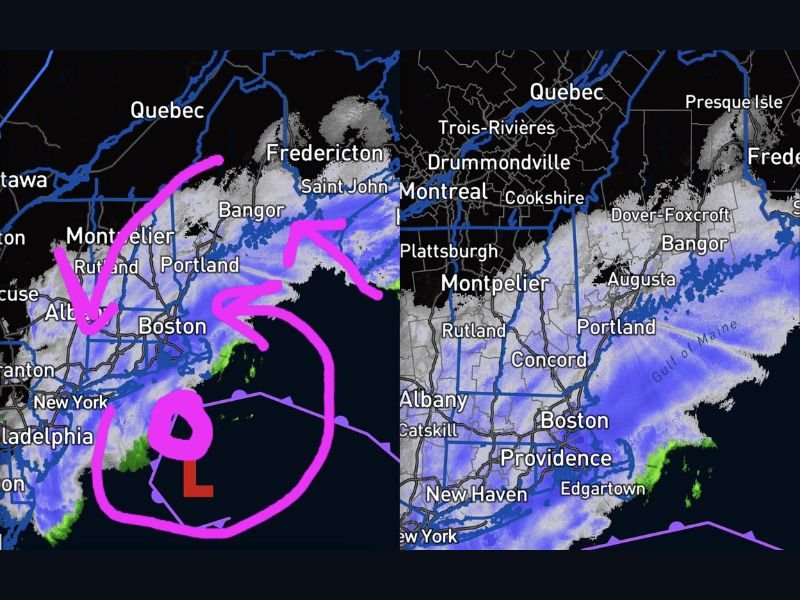
Radar imagery shows the heaviest activity stretching from Boston north through Portland, Maine, and toward Bangor. Snow is still wrapping around the storm’s western flank, but coverage becomes less organized the farther inland you travel.
Communities like Concord, New Hampshire, Montpelier, Vermont, and Albany, New York, are seeing lighter snowfall compared to coastal sections. This matches earlier projections that snow would struggle to push far inland on the storm’s northern and western edges.
Why Inland Totals Are Lower
A key factor limiting snowfall inland is the presence of cold, dry air wrapping into the northern side of the system. As snow attempts to advance inland, that dry air essentially “eats away” at the northern edge of precipitation, weakening bands before they can expand deeper into areas like interior Vermont, upstate New York, and western Massachusetts.
This has led to sharp snowfall gradients — meaning some areas wake up to substantial totals while others, not far away, see far less accumulation than initially expected.
While some residents anticipated up to two feet of snow, those extreme totals appear more isolated and primarily confined to coastal and immediate near-coastal communities.
Coastal Maine Still in the Game
Snow is intensifying along coastal Maine, particularly around Portland and northward toward Bangor. With several hours of banding still expected, accumulations will continue to climb before the system finally pulls away later today.
Boston and surrounding eastern Massachusetts communities remain under steady snowfall as well, though intensity may fluctuate as individual bands pivot through.
Travel and Ongoing Impacts
Even as the storm center shifts east of Cape Cod, hazardous travel conditions persist across eastern Massachusetts and coastal Maine. Roads remain snow-covered, and visibility can quickly drop when stronger bands rotate through.
Airports across the region have already experienced significant disruptions, and lingering snow will likely delay full recovery of travel operations.
What Happens Next
As the storm tracks farther out to sea, snowfall will gradually taper from west to east. Inland areas such as Albany, Concord, and Montpelier should see improving conditions first, while coastal Maine may hold onto snow the longest.
The overall trend now favors continued coastal impacts with limited inland expansion, reinforcing the idea that this storm’s heaviest punch remains tied to the shoreline. For continued national weather coverage and updates on major storm systems, stay connected with NapervilleLocal.com.

I’ve lived in Naperville long enough to see how quickly our community changes — from new developments downtown to sudden shifts in our Midwest weather. Reporting on Naperville news and daily forecasts gives me the chance to keep neighbors informed about what really matters. My goal is simple: deliver clear, timely updates so you always know what’s happening in our city and what to expect from the skies above.