
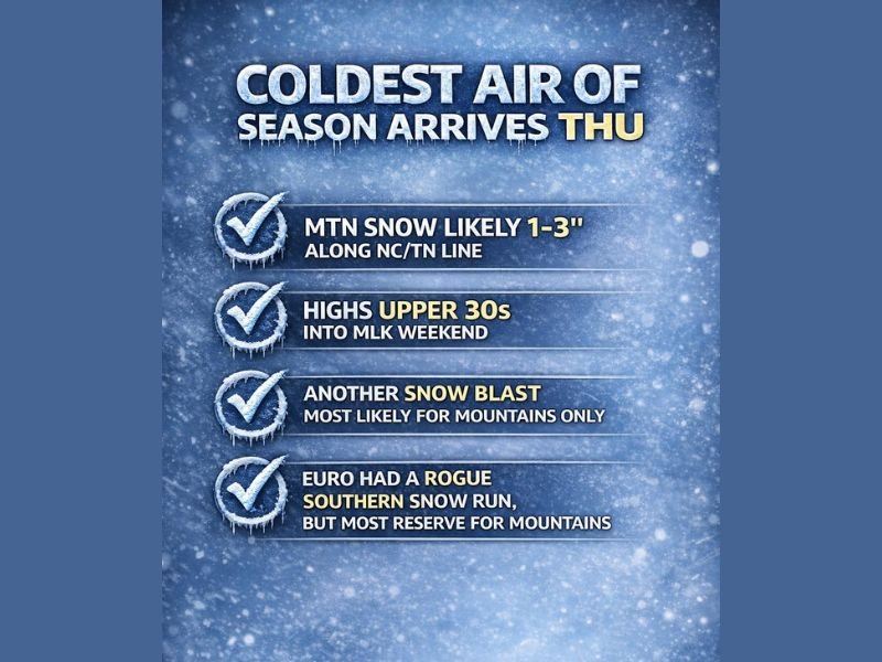
North Carolina and Tennessee Face Coldest Air of the Season as Mountain Snow Becomes Increasingly Likely
NORTH CAROLINA / TENNESSEE — The coldest air mass of the season is set to arrive Thursday, bringing a sharp temperature drop across the southern Appalachians and reinforcing a winter pattern that forecasters say is among the snowiest seen in years. While widespread snow outside the mountains continues to look uncertain, mountain snowfall along the North Carolina–Tennessee border is becoming increasingly likely as confidence grows in colder, drier air settling in. Meteorologists reviewing overnight model runs say the overall pattern strongly favors mountain impacts rather than broad southern snow.
Forecast Models Continue to Favor Mountain Snow Over Widespread Southern Accumulation
Recent guidance shows the GFS model gradually aligning more closely with the European model, which has consistently favored snow confined to higher elevations rather than widespread snowfall across the Deep South. While one European operational run briefly hinted at a southern snow scenario overnight, the full European ensemble rejected that solution, signaling it was likely an anomaly rather than a trend. Forecasters note that when ensemble data does not support an operational run, confidence in that outcome drops sharply.
Snow Outside the Mountains Remains Possible but Far From Certain
Despite the highly wintry setup, forecasters caution that areas outside the mountains may remain too dry, even with cold air firmly in place. This could limit snow potential for lower elevations across North Carolina, Tennessee, and the broader Deep South, despite temperatures being cold enough to support wintry precipitation. The bottom line from current data is that cold alone will not be enough without sufficient moisture.
Key Time Windows for Potential Snow Development
Forecasters are closely watching several upcoming periods that could offer snow chances, especially in the mountains.
- The first window arrives Thursday, coinciding with the leading edge of the coldest air of the season.
- The second opportunity appears during the MLK weekend, though confidence remains moderate.
- A third, lower-confidence window may emerge around the 23rd, as the broader pattern begins to shift again.
Each of these periods will depend heavily on how moisture interacts with the cold air mass.
What to Expect in the Mountains Versus Lower Elevations
In the higher elevations along the North Carolina–Tennessee line, 1 to 3 inches of snow is increasingly likely, particularly in favored mountain zones. High temperatures are expected to struggle into the upper 30s, reinforcing winter conditions through the MLK weekend. Outside the mountains, snow remains possible but not locked in, with many areas potentially staying dry despite the cold.
Active Winter Pattern Continues to Demand Close Monitoring
Forecasters emphasize that this remains an active and volatile winter pattern, requiring careful monitoring of each new model run. While southern snow continues to disappoint for now, the persistence of cold air and repeated storm signals means winter is far from over for the Southeast.
NapervilleLocal.com will continue tracking these evolving winter patterns and provide updates as confidence sharpens and new data becomes available.

I’ve lived in Naperville long enough to see how quickly our community changes — from new developments downtown to sudden shifts in our Midwest weather. Reporting on Naperville news and daily forecasts gives me the chance to keep neighbors informed about what really matters. My goal is simple: deliver clear, timely updates so you always know what’s happening in our city and what to expect from the skies above.