
North Carolina Braces for Widespread Sunday Rain as Low-Pressure System Brings 40s and 50s Statewide and 60s Along the Coast
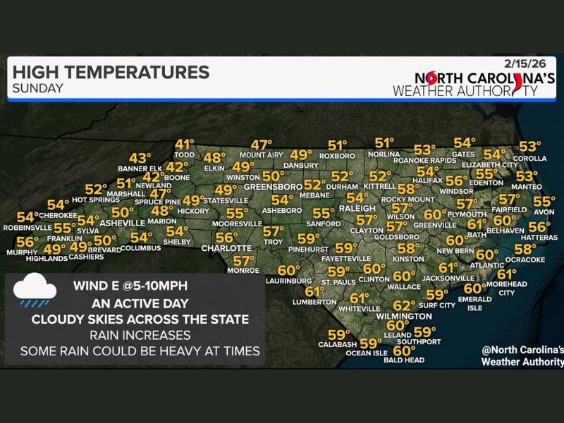
Raleigh, North Carolina — A much more active weather pattern is unfolding across the state on Sunday, February 15, 2026, as a low-pressure system moves across North Carolina, bringing scattered to numerous rain showers, cloudy skies, and a wide range of temperatures from the 40s in the mountains to the low 60s along the coast. Some pockets of heavier rainfall are possible throughout the day.
The system is spreading moisture statewide, with east winds at 5–10 mph helping keep skies mostly cloudy. While the rain will not be constant everywhere, most communities can expect periods of showers before the system gradually moves out.
Mountains and Foothills Stay Cool in the 40s and Low 50s
Western North Carolina will remain the coolest region of the state. Banner Elk (43°), Boone (42°), and Todd (41°) are among the coldest locations, while Asheville (50°) and Brevard (49°) see slightly milder readings.
Communities such as Hickory (49°), Statesville (49°), and Elkin (48°) reflect the broader 40s trend across the foothills. The cooler temperatures combined with steady cloud cover will make for a damp, gray day across higher elevations. Though no wintry precipitation is indicated, persistent cloud cover and occasional showers will keep conditions feeling chilly in these areas.
Piedmont and Triangle See Mid-50s With Increasing Rain
Central portions of the state will experience slightly warmer conditions. Greensboro (50°), Winston-Salem (49°), and Danbury (49°) remain near the 50-degree mark, while the Triangle region is forecast to climb into the mid-50s.
Durham (52°), Raleigh (54°), and Sanford (55°) will likely see steady cloud cover with periods of rain. Fayetteville (59°) and Clinton (60°) sit near the warmer edge of the central zone as moisture increases throughout the afternoon.
Rain coverage will vary, but forecasters indicate some areas could experience heavier downpours at times as the low-pressure center tracks eastward.
Eastern North Carolina Climbs Into the 60s
The warmest readings are expected across eastern North Carolina and along the coast. Greenville (60°), New Bern (60°), and Jacksonville (61°) highlight the milder air mass in place ahead of the system. Coastal communities including Wilmington (62°), Morehead City (61°), and Emerald Isle (60°) will feel the most spring-like conditions despite ongoing cloud cover.
Further north along the Outer Banks, Elizabeth City (54°), Edenton (55°), and Manteo (53°) remain cooler but still above seasonal averages. The combination of warmer air and steady rainfall may lead to localized heavier showers, especially in eastern counties.
Overall, Sunday brings widespread cloud cover, periodic rainfall, and a clear temperature divide between western mountains and the coastal plain. While severe weather is not highlighted, residents should plan for wet roads and slower travel at times. For continued coverage of significant weather developments across the country, visit NapervilleLocal.com for in-depth regional reporting and daily updates.

I’ve lived in Naperville long enough to see how quickly our community changes — from new developments downtown to sudden shifts in our Midwest weather. Reporting on Naperville news and daily forecasts gives me the chance to keep neighbors informed about what really matters. My goal is simple: deliver clear, timely updates so you always know what’s happening in our city and what to expect from the skies above.