
North Carolina Faces a Cold Sunday With Temps in the 10s, Then a Midweek Jump Into the 50s and 60s
NORTH CAROLINA — A cold Sunday is taking hold across the state, with many communities starting the morning in the teens and daytime temperatures expected to stay mostly in the 30s and 40s. Forecasters say skies will be mostly sunny for much of the day, though clouds may increase later, and a brief warmup is expected to arrive Tuesday and Wednesday with highs climbing into the 50s and 60s for many areas.
Cold Morning Start: Many Spots Begin the Day in the Teens
The overall message is clear: it’s a cold start statewide. Even where the sun is out early, the air mass is cold enough that many residents are beginning the day bundled up, especially across inland communities.
Sunday Highs: Mostly 30s and 40s Across the State
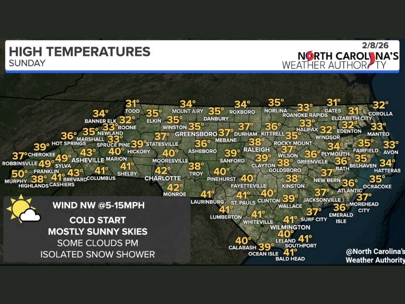
High temperatures on the map show most of North Carolina stuck in classic mid-winter numbers.
A few notable highs shown across the state include:
- Raleigh: 38°
- Durham: 37°
- Greensboro: 35°
- Charlotte: 42°
- Fayetteville: 40°
- Wilmington: 41°
- Jacksonville: 37°
- Boone: 32°
- Asheville: 43°
- Banner Elk: 34°
- Elizabeth City: 31°
- Morehead City: 37°
- Outer Banks (Hatteras area): mid-30s
These numbers reinforce what most people will feel outside today: cold but manageable, especially with sunshine.
Sky Conditions and Wind: Mostly Sunny, Then Clouds Increase
Forecasters call for mostly sunny skies for much of Sunday, with some clouds building during the afternoon. Winds are expected to come from the northwest around 5–15 mph, which can add a noticeable chill—especially during the morning and in exposed areas.
Snow Chance: A Passing Snow Shower Can’t Be Ruled Out
While this is not being described as a widespread snow event, forecasters note they can’t rule out an isolated snow shower this afternoon, mainly for parts of Central and Western North Carolina. If one develops, it would likely be brief and hit-or-miss rather than a long-duration setup.
Warmup Watch: Tuesday and Wednesday Could Reach the 50s and 60s
After today’s cold, a short warmup is expected to arrive Tuesday into Wednesday, with highs forecast to rise into the 50s and 60s for many communities. That’s a noticeable swing compared to Sunday’s 30s and 40s, and it could change how the rest of the week feels—at least temporarily.
If you’re in North Carolina, what did you wake up to this morning—teens, 20s, or already near 30? Share your local reading and what you’re seeing outside in the comments on NapervilleLocal.com.

I’ve lived in Naperville long enough to see how quickly our community changes — from new developments downtown to sudden shifts in our Midwest weather. Reporting on Naperville news and daily forecasts gives me the chance to keep neighbors informed about what really matters. My goal is simple: deliver clear, timely updates so you always know what’s happening in our city and what to expect from the skies above.