
North Carolina Faces Snow Forecast Whiplash as NAM Signals Significant Western Accumulation While EURO Says No
NORTH CAROLINA — Winter weather forecasts took a sharp turn early this morning as major weather models split dramatically on whether accumulating snow will impact the western Carolinas, raising uncertainty just days ahead of the potential event.
While some guidance now shows notable snowfall piling up across western North Carolina, other respected models paint a very different picture — leaving forecasters closely watching upcoming updates before confidence increases.
NAM, GFS, and American Models Show Snow in Western Carolinas
Early morning runs of the NAM, GFS, and American Suite models are in agreement on one key point: accumulating snow is possible across parts of western North Carolina, including higher elevations and nearby foothills.
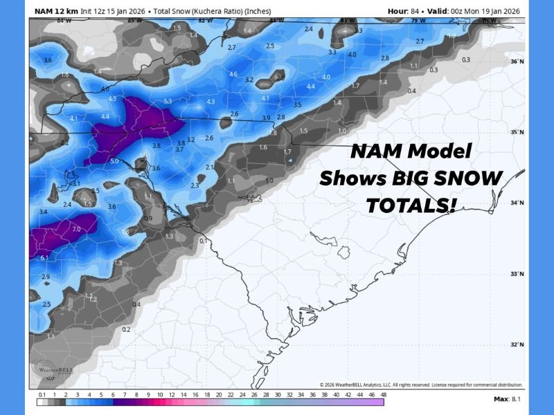
The NAM model, which is known for its higher resolution and ability to capture terrain-driven snowfall, is showing some of the highest totals, with pockets of several inches possible if the current solution verifies. These totals are being driven by a favorable cold air setup combined with moisture tracking inland from the west.
Because of the NAM’s resolution advantage, its solution cannot be dismissed, especially in complex terrain where small track changes can make a major difference.
EURO Model Pushes Snow East, Leaves Western Areas Dry
In contrast, the EURO model tells a much different story. Its latest run shows little to no snow across western North Carolina, instead keeping any meaningful accumulation closer to the coast, where only a brief or glancing impact would be expected.
This sharp disagreement between the EURO and American guidance highlights just how sensitive the setup remains, with slight shifts in temperature profiles and storm track playing an outsized role in the outcome.
Why Forecast Confidence Remains Low Right Now
At this stage, forecasters caution against locking into any single model solution. Key factors still in flux include:
- Exact storm track placement
- Cold air depth and timing
- Moisture availability inland
- Elevation-driven enhancement potential
Adding to the uncertainty, a new NAM run is currently processing, which could either reinforce the snowy western solution or trend toward a warmer, drier outcome. Until those updates arrive, confidence in specific snowfall totals remains limited.
What Residents Should Watch Over the Next 24 Hours
For now, residents across western and central North Carolina should stay alert for forecast updates, especially those in higher elevations where small changes could lead to big differences in impacts.
If the NAM scenario holds, travel disruptions and slick roads could become a concern. If the EURO solution wins out, many inland areas may see little more than cold temperatures and clouds. The next round of model updates will be critical in determining which scenario becomes more likely.
For continued winter weather updates, model breakdowns, and developing snowfall forecasts across the region, follow the latest reports on NapervilleLocal.com and share what conditions you’re seeing where you live.

I’ve lived in Naperville long enough to see how quickly our community changes — from new developments downtown to sudden shifts in our Midwest weather. Reporting on Naperville news and daily forecasts gives me the chance to keep neighbors informed about what really matters. My goal is simple: deliver clear, timely updates so you always know what’s happening in our city and what to expect from the skies above.