
North Carolina Hard Freeze and Flash Freeze Threat Tonight as Temperatures Plunge Into the 20s and Black Ice Risk Increases Statewide
NORTH CAROLINA — A sharp drop in temperatures is underway tonight as colder air surges across the state, pushing readings below freezing and creating the potential for a flash freeze. Any lingering moisture from earlier precipitation that does not evaporate before nightfall is expected to freeze overnight, increasing the risk of isolated black ice, especially on bridges, overpasses, and elevated walkways.
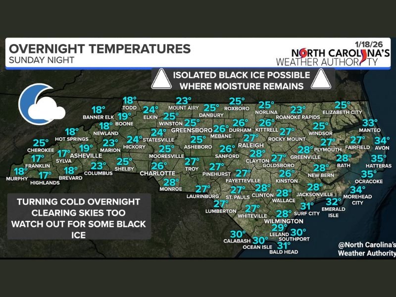
Overnight low temperatures are forecast to fall into the upper teens and 20s across much of the state, with a widespread hard freeze expected to last through the early hours of Monday morning.
Why Black Ice Is a Concern Overnight
As skies clear and winds ease, rapid radiational cooling will allow surface temperatures to drop quickly. Areas that remain damp — even from minor runoff or melting — could freeze suddenly, forming hard-to-see ice patches.
Black ice is most likely to develop on:
- Bridges and overpasses
- Elevated roadways and ramps
- Sidewalks, walkways, and shaded areas
- Roads that remain wet into the late evening
Even roads that appear dry in spots could become slick overnight as temperatures continue to fall.
Overnight Temperatures Drop Into the Upper Teens and 20s
Forecast lows show widespread freezing conditions:
- Upper teens in parts of the mountains and foothills
- Lower to mid-20s across the Piedmont
- Upper 20s to near 30 closer to the coastal plain
These temperatures are cold enough to refreeze any remaining surface moisture and maintain icy conditions into the early morning commute.
Timing: When Conditions Will Be Most Hazardous
The most hazardous travel conditions are expected:
- Late Sunday night through early Monday morning
- During the pre-dawn and early commute hours
- Until temperatures rise above freezing after sunrise
While widespread icing is not expected, isolated slick spots could still cause issues, especially in areas where moisture lingers.
What Drivers and Pedestrians Should Do
Residents are urged to use extra caution overnight and Monday morning:
- Slow down when driving, especially on elevated roads
- Avoid sudden braking or sharp turns on bridges
- Use handrails and watch footing on sidewalks and stairs
- Allow extra travel time during the morning commute
Conditions can vary widely over short distances, making black ice especially dangerous.
The Bottom Line
A hard freeze tonight combined with leftover moisture creates a real risk for isolated black ice through Monday morning. While not everyone will encounter slick conditions, those who do may find them suddenly and without warning. Staying alert and cautious will be key until temperatures rebound later Monday.
For continued cold-weather updates, road condition alerts, and local safety information, stay connected with NapervilleLocal.com and share how these overnight conditions are affecting your area.

I’ve lived in Naperville long enough to see how quickly our community changes — from new developments downtown to sudden shifts in our Midwest weather. Reporting on Naperville news and daily forecasts gives me the chance to keep neighbors informed about what really matters. My goal is simple: deliver clear, timely updates so you always know what’s happening in our city and what to expect from the skies above.