
North Carolina High Temperatures for February 28, 2026 Bring Morning Fog and Afternoon Highs in the 50s and 60s Statewide
North Carolina — A gradual warming trend is unfolding across the state on Saturday, February 28, 2026, as morning fog and cloud cover give way to clearing skies and afternoon highs in the 50s and 60s. The statewide forecast highlights a calm weather pattern with light north winds at 5 to 10 mph, areas of dense fog early, and improving conditions heading into the evening.
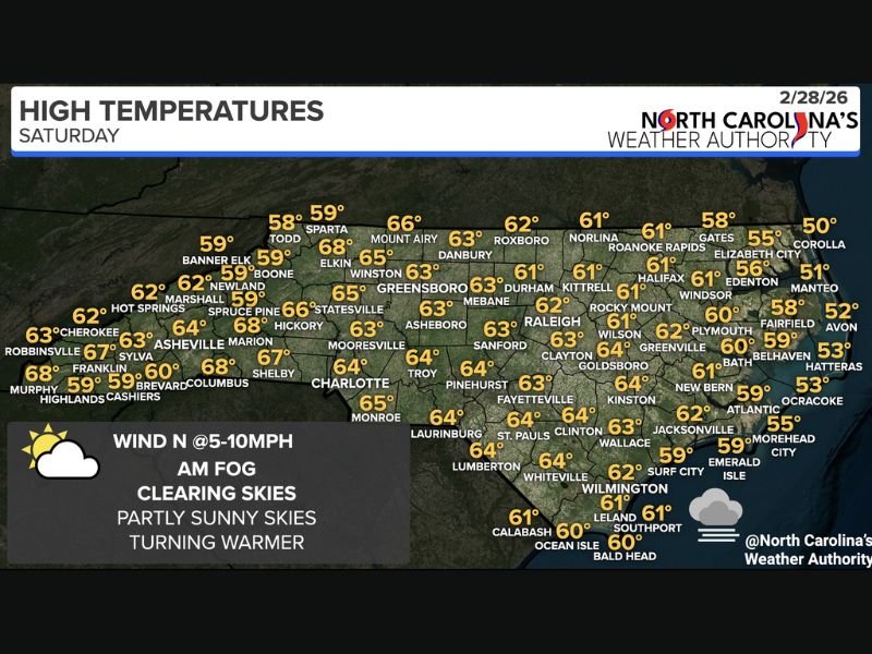
According to the official high temperature outlook from North Carolina’s Weather Authority , most communities will experience a mild late-winter afternoon, with inland regions warming more efficiently than coastal areas.
Morning Fog and Gradual Afternoon Clearing
The day begins with widespread cloud cover and pockets of dense fog, particularly in low-lying and rural areas. Visibility may be reduced during the early morning commute, but conditions are expected to steadily improve through late morning.
By afternoon, skies turn partly sunny, allowing temperatures to climb several degrees above recent cooler stretches. While no major storm systems are impacting the region, the fog indicates lingering surface moisture interacting with light winds.
The overall pattern suggests stable air and limited weather hazards. No precipitation is shown on the forecast map , and the combination of light wind and clearing skies supports a quiet weather day across all regions of the state.
Western and Central North Carolina See the Warmest Highs
Communities in the mountains and western foothills are forecast to see some of the warmer readings statewide. Areas benefiting from stronger afternoon sunshine may climb into the mid to upper 60s.
Forecast highs include:
- Franklin: 67°
- Marion: 68°
- Hickory: 66°
- Asheville: 64°
- Shelby: 67°
- Charlotte: 64°
- Greensboro: 63°
- Winston-Salem: 65°
In central regions, temperatures remain comfortably mild:
- Durham: 61°
- Raleigh: 62°
- Sanford: 63°
- Fayetteville: 64°
- Goldsboro: 64°
- Kinston: 64°
These readings reflect a steady transition toward early March conditions, with daytime warmth increasing under partial sunshine.
Mountain communities such as Boone and Banner Elk remain cooler at 59°, while Mount Airy stands out slightly warmer at 66°, illustrating how elevation continues to influence temperature variation across the state.
Coastal Areas Remain Cooler Under Marine Influence
Along North Carolina’s coastline and the Outer Banks, temperatures remain notably cooler due to proximity to the Atlantic Ocean.
Forecast highs along the coast include:
- Corolla: 50°
- Manteo: 51°
- Avon: 52°
- Hatteras: 53°
- Ocracoke: 53°
- Morehead City: 55°
- Emerald Isle: 59°
- Wilmington: 59°
- Southport: 61°
While skies will also clear along the coast, ocean influence prevents temperatures from rising into the mid or upper 60s like inland areas. This temperature gradient is typical during late winter when land surfaces warm more quickly than surrounding waters.
Eastern inland cities such as Greenville (62°), Rocky Mount (61°), and Wilson (61°) sit between the cooler coast and warmer interior, highlighting the regional variation across North Carolina.
What This Pattern Means Heading Into March
The February 28 forecast signals a stable and gradually moderating air mass settling over North Carolina. With no storm systems in play and only light northerly winds, the state is positioned for a calm close to the month.
Morning fog remains the primary concern, especially for early drivers. However, once visibility improves, residents can expect a comfortable afternoon with manageable temperatures statewide.
The absence of rain or severe weather also suggests a relatively quiet transition into early March. Continued warming trends could follow if sunshine persists in the coming days.
Residents are encouraged to monitor local forecasts for any overnight fog advisories or visibility updates. For continued statewide weather coverage, detailed temperature maps, and regional forecast analysis, visit NapervilleLocal.com for the latest reports.

I’ve lived in Naperville long enough to see how quickly our community changes — from new developments downtown to sudden shifts in our Midwest weather. Reporting on Naperville news and daily forecasts gives me the chance to keep neighbors informed about what really matters. My goal is simple: deliver clear, timely updates so you always know what’s happening in our city and what to expect from the skies above.