
North Carolina Mountains Braced for Significant Snowfall as Cold Front Triggers Northwest Flow Snow Event
North Carolina — A strong cold front moving through the Southeast is expected to trigger a classic northwest flow snow event across the North Carolina mountains, bringing accumulating snowfall Wednesday night into Thursday, especially at elevations above 3,000 feet. Forecast data shows that higher ridgelines near the Tennessee border could receive several inches of snow, with the heaviest totals confined to the highest peaks.
Meteorologists say confidence is increasing that this will be a terrain-driven snow event, where elevation plays a decisive role in how much snow falls.
Snow Accumulation Focused on Higher Elevations
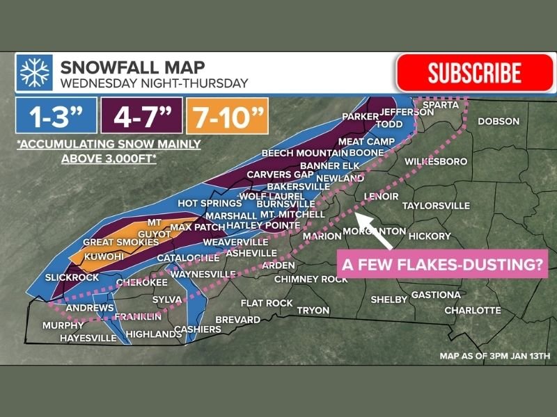
According to the latest snowfall projections, accumulating snow is likely mainly above 3,000 feet, with amounts increasing sharply above 3,500 feet. Communities along the North Carolina–Tennessee border are expected to see the greatest impacts.
Forecast ranges indicate:
- 1 to 3 inches for elevations just above 3,000 feet
- 4 to 7 inches across many high mountain communities
- 7 to 10 inches or more possible on the highest peaks and exposed ridgelines
A few ridgetop locations could exceed 9 inches, particularly in the Smokies and the highest portions of the Blue Ridge.
Heaviest Snow Near the Tennessee Border and Highest Peaks
The most significant snowfall is expected in and around:
- The Great Smoky Mountains
- Mount Mitchell
- Clingmans Dome (Kuwohi)
- Max Patch
- Roan Mountain and Carvers Gap
- Western-facing ski resort areas
- Portions of the Blue Ridge Parkway
These areas are especially vulnerable because northwest winds will force cold air upslope, enhancing snowfall through orographic lift.
Strong Winds May Create Blowing Snow
As the cold front passes Wednesday night, northwest wind gusts of 35 to 45 mph are expected in higher elevations. These winds could lead to blowing and drifting snow, further reducing visibility and making travel difficult in exposed mountain passes. Even where snowfall totals are modest, wind-driven snow can create slick and hazardous road conditions, especially overnight and early Thursday.
Lower Elevations See Little Impact
Valleys and lower elevations across western North Carolina may see a few flakes or a brief dusting, but little to no accumulation is expected below 3,000 feet. Areas farther east — including the foothills and Piedmont — are unlikely to see meaningful snowfall. This sharp contrast is typical of northwest flow snow events, where elevation is the primary factor determining impact.
Timing of the Snow Event
Snow is expected to begin Wednesday afternoon in the highest elevations, becoming more widespread Wednesday night into early Thursday. Snow showers may continue intermittently through Thursday before gradually tapering off as drier air moves in. Temperatures will turn noticeably colder statewide, reinforcing winter conditions across the region.
Travel Concerns in the Mountains
Officials caution that slick roads are likely across mountain highways, particularly:
- Along higher-elevation routes
- Near mountain gaps and ridgelines
- On stretches of the Blue Ridge Parkway
Drivers traveling through western North Carolina late Wednesday or Thursday should prepare for rapidly changing road conditions, especially above 3,000 feet.
Why This Matters for Midwest Readers
While this snow event is not impacting Illinois, meteorologists note it is part of a broader winter pattern affecting much of the eastern United States. Systems like this highlight how strong cold fronts can still generate impactful winter weather in specific terrain-driven regions, even when surrounding areas remain largely unaffected. NapervilleLocal.com continues to monitor national weather patterns to provide context on how evolving winter systems behave across the country.

I’ve lived in Naperville long enough to see how quickly our community changes — from new developments downtown to sudden shifts in our Midwest weather. Reporting on Naperville news and daily forecasts gives me the chance to keep neighbors informed about what really matters. My goal is simple: deliver clear, timely updates so you always know what’s happening in our city and what to expect from the skies above.