
North Carolina Nears Record Warmth as Highs Surge into the 70s Statewide with Only Spotty Showers Up North
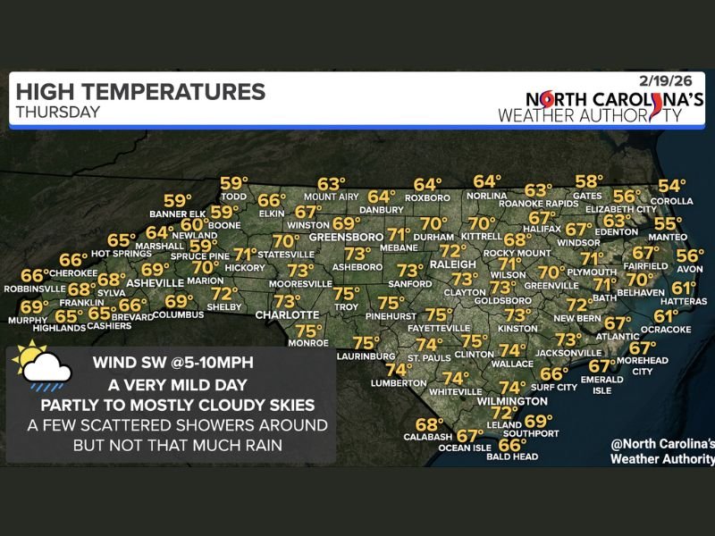
NORTH CAROLINA — A mild and unusually warm pattern is settling across the state Thursday, with temperatures climbing into the 60s and 70s statewide, pushing close to record highs for mid-February in many communities.
A frontal boundary positioned to the north will focus the best chance for scattered showers across northern North Carolina, while southern areas remain largely dry with only increased cloud cover.
Near-Record Warmth Across Central and Southern Cities
Much of central and southern North Carolina will experience spring-like warmth.
Forecast highs include:
- Charlotte – 73°
- Greensboro – 69°
- Durham – 70°
- Raleigh – 72°
- Fayetteville – 75°
- Pinehurst – 75°
- Monroe – 75°
- Laurinburg – 75°
- Lumberton – 74°
- Wilmington – 72°
These readings are well above seasonal averages and approach record territory in several spots.
Northern North Carolina: Milder with Passing Showers
Northern communities will still see mild conditions but with slightly cooler highs and a better chance of scattered showers as the front lingers nearby.
Projected highs include:
- Mount Airy – 63°
- Danbury – 64°
- Roxboro – 64°
- Roanoke Rapids – 63°
- Elizabeth City – 56°
- Gates – 58°
- Corolla – 54°
While rainfall coverage remains limited, increased cloud cover and passing showers will be more common in these northern zones compared to areas farther south.
Coastal and Eastern North Carolina Conditions
Eastern and coastal cities will also enjoy mild temperatures with a mix of clouds and sun.
Highs include:
- Greenville – 70°
- New Bern – 72°
- Jacksonville – 73°
- Atlantic Beach – 67°
- Emerald Isle – 67°
- Morehead City – 67°
- Hatteras – 61°
- Ocracoke – 61°
Beach communities will remain cooler than inland cities but still above typical February levels.
Winds and Overall Setup
Winds are expected out of the southwest at 5–10 mph, helping transport warmer air across the state. Skies will be partly to mostly cloudy, with only limited rainfall overall.
While northern counties may see passing showers, widespread or heavy rain is not expected. The primary story remains the unseasonably warm air mass dominating much of North Carolina.
For continued regional weather updates and national coverage affecting communities across the country, stay connected with NapervilleLocal.com for the latest developments.

I’ve lived in Naperville long enough to see how quickly our community changes — from new developments downtown to sudden shifts in our Midwest weather. Reporting on Naperville news and daily forecasts gives me the chance to keep neighbors informed about what really matters. My goal is simple: deliver clear, timely updates so you always know what’s happening in our city and what to expect from the skies above.