
North Carolina Shivers Under Late-Season Chill as Mountain Snow and Breezy Winds Keep Highs Stuck in the 40s
NORTH CAROLINA — A sharp return to winter-like conditions is sweeping across North Carolina this Tuesday, bringing chilly temperatures, gusty winds, and even the chance for snow in higher elevations.
Residents across the state are waking up to a noticeably colder start, with forecasters warning that temperatures will struggle to climb much throughout the day.
Cold Air Grips the Entire State
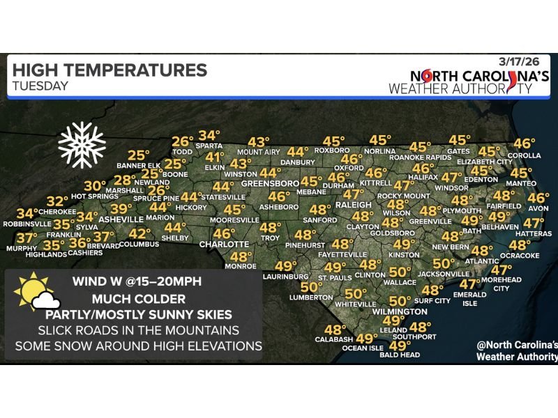
After recent mild conditions, a colder air mass has settled in across North Carolina, dropping temperatures significantly. Most areas across the state are expected to see afternoon highs only in the 40s, a clear sign that winter is not ready to let go just yet.
Cities including:
- Greensboro – around 44°F
- Charlotte – near 46°F
- Raleigh – around 47°F
- Durham – near 46°F
will all remain locked in a cool and breezy pattern through the day. Even along the coast, temperatures will stay relatively mild but still below seasonal expectations, with readings generally in the upper 40s to near 50°F.
Mountain Areas See Snow and Freezing Conditions
The coldest conditions will be found in western North Carolina’s mountain regions.
Temperatures there are expected to remain in the:
- 20s and low 30s in higher elevations
Locations such as:
- Boone – near 25°F
- Banner Elk – around 25°F
- Sparta – near 34°F
could see periodic snow showers, especially at higher elevations.
Forecasters are also warning about slick and icy road conditions, particularly in shaded or elevated areas where temperatures remain below freezing.
Gusty Winds Add to the Chill
Adding to the discomfort will be steady west winds moving across the state.
Forecast wind conditions include:
- West winds at 15 to 20 mph
These winds will make temperatures feel even colder, especially during the morning hours, and could create challenging conditions for travel in exposed areas.
Skies Stay Bright but Deceptively Cold
Despite the colder air, much of North Carolina will experience partly to mostly sunny skies throughout the day.
However, the sunshine will do little to warm things up, as the cold air mass remains firmly in place. This combination of sun and chill may catch some residents off guard, especially after recent warmer days.
Travel Concerns in the Mountains
Drivers traveling through western North Carolina should remain alert.
Officials warn that:
- Snow showers could develop at times
- Roads may become slick, especially early and late in the day
- Higher elevations will see the most impact
Even brief snow bursts could create hazardous driving conditions.
A Reminder That Winter Isn’t Done Yet
This latest cold snap is a reminder that late-season swings are still possible across the Southeast, even as spring approaches.
While temperatures are expected to gradually moderate later in the week, for now, North Carolina residents should prepare for a day that feels much more like mid-winter than mid-March.
Officials urge everyone to dress warmly, drive cautiously in mountain areas, and stay updated on changing conditions as this cold pattern moves through the state. Stay with NapervilleLocal.com for continued national weather updates impacting communities across the country.

I’ve lived in Naperville long enough to see how quickly our community changes — from new developments downtown to sudden shifts in our Midwest weather. Reporting on Naperville news and daily forecasts gives me the chance to keep neighbors informed about what really matters. My goal is simple: deliver clear, timely updates so you always know what’s happening in our city and what to expect from the skies above.