
North Carolina Snow Chances Rise Sunday as Charlotte and Piedmont Face Low-Impact but Uncertain Setup
North Carolina — Updated ensemble guidance shows a measurable but uncertain snow setup for Sunday across Charlotte and much of the Piedmont, with probabilities favoring light snowfall or a brief accumulation rather than a high-impact winter storm. While confidence remains limited, the data confirms this is not a zero-chance event, particularly north and east of the Charlotte metro area.
Forecasters emphasize that this outlook is based on probability distributions, not deterministic snowfall maps, highlighting why expectations should remain measured as the forecast window tightens.
What the Latest Snow Probabilities Show for Charlotte and the Piedmont
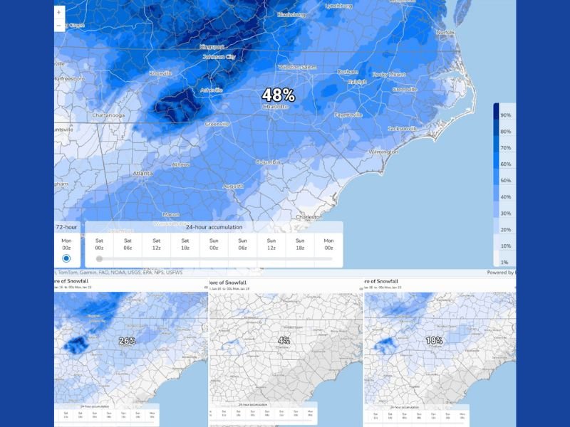
According to the most recent ensemble guidance, snowfall odds for Charlotte and surrounding Piedmont communities break down as follows:
- 48% chance of at least a trace (0.1″)
- 26% chance of 1 inch or more
- 18% chance of 2 inches or more
- 4% chance of 4 inches or more
These numbers indicate that light snow is clearly on the table, while higher totals drop off quickly in likelihood. The most probable outcome at this stage is a glancing or low-impact snowfall, rather than a disruptive winter event.
Why This Is Not a Locked-In Snow Event
Despite rising attention, this setup remains highly sensitive to timing, track, and cold air depth. Small shifts in any of those variables could significantly reduce — or modestly increase — snowfall amounts.
Meteorologists stress that probabilities matter because they reflect ranges of outcomes, not guarantees. Most solutions currently cluster on the low-impact side, but the presence of non-zero higher totals confirms that uncertainty remains meaningful.
This is especially true with marginal southern snow setups, where slight temperature changes can determine whether precipitation falls as snow, sleet, or cold rain.
Higher Snow Odds North and East of Charlotte
One consistent signal in the data is that higher snow probabilities increase north and east of Charlotte, extending deeper into portions of the central and eastern Piedmont. This aligns with expectations that colder air may hold more firmly in those areas as the system moves through.
Locations closer to the I-85 corridor south and west of Charlotte remain more vulnerable to mixing or reduced snowfall, reinforcing the idea that local impacts could vary sharply over short distances.
What Residents Should Take Away Right Now
At this stage, the forecast supports three key conclusions:
- Plenty of uncertainty remains with multiple possible outcomes
- Light snow is a realistic possibility, especially Sunday
- Significant accumulations are unlikely, but not impossible
This is not a forecast calling for widespread closures or major travel disruptions. Instead, it is a low-confidence, low-impact winter setup that deserves monitoring — particularly for elevated or untreated roadways during early morning hours.
Why the Forecast Will Change as Sunday Approaches
As the event moves inside the 48-hour window, higher-resolution models will better resolve:
- Moisture availability
- Thermal profiles near the surface
- Exact timing of precipitation
Those details will determine whether snow remains a brief novelty or becomes a more meaningful accumulation in select areas. Until then, forecasters caution against reacting to single model runs or isolated snowfall maps, emphasizing that the math still favors lighter outcomes.
For continued updates on winter weather trends, probability-based forecasts, and regional impacts across the U.S., stay with NapervilleLocal.com, where we break down developing weather patterns clearly and without exaggeration.

I’ve lived in Naperville long enough to see how quickly our community changes — from new developments downtown to sudden shifts in our Midwest weather. Reporting on Naperville news and daily forecasts gives me the chance to keep neighbors informed about what really matters. My goal is simple: deliver clear, timely updates so you always know what’s happening in our city and what to expect from the skies above.