
North Carolina, South Carolina, and Georgia Face Two Incoming Cold Fronts That Could End Warm Spell and Bring Frost Threat Around March 16–19
Southeastern United States — A stretch of unusually warm early-March weather across the Southeast may soon come to an abrupt end as two separate cold fronts are forecast to move across the region during the next two weeks, potentially bringing a return of chilly conditions and even a frost or freeze threat in mid-March.
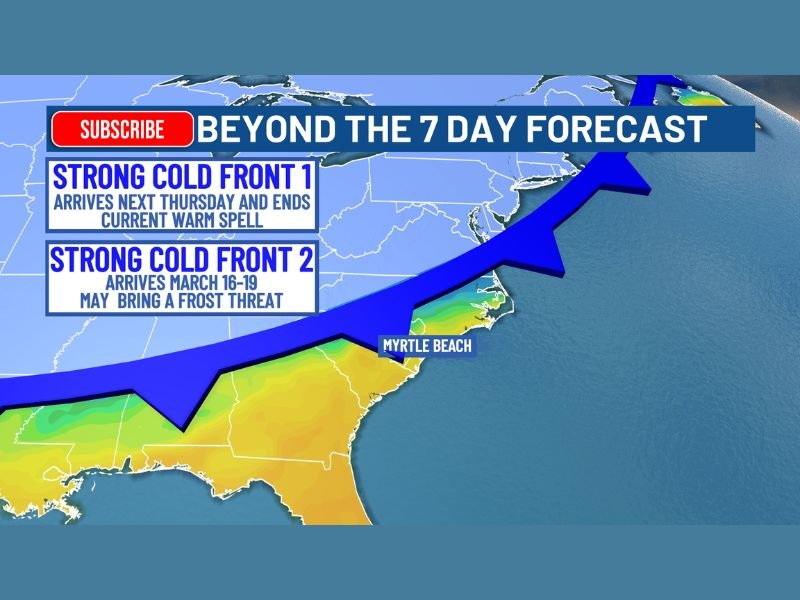
Meteorologists say the first cold front is expected to arrive next Thursday, which will likely break the current warm spell that has pushed temperatures well above seasonal averages across several southeastern states. A second, stronger cold front could follow between March 16 and March 19, and forecasters warn this system could deliver a sharper drop in temperatures — possibly cold enough for frost in some areas.
First Cold Front Expected to End Current Warm Pattern
The first weather system expected to impact the Southeast will move through late next week, bringing cooler air behind it and signaling a shift away from the current warm pattern.
This front will likely cause temperatures to fall back closer to seasonal levels, ending several days of springlike warmth that have dominated the region. Although this first system is not expected to produce major cold outbreaks, meteorologists say it will mark the beginning of a transition toward a cooler weather pattern.
Communities across the Carolinas, Georgia, and parts of the Gulf Coast region may notice the change as temperatures drop after the front moves through.
Stronger Cold Front Could Arrive Mid-March
The second system, forecast to arrive around March 16 through March 19, could be much more impactful.
Meteorologists say this front may push a larger surge of colder air southward, potentially creating conditions favorable for frost or freezing temperatures across parts of the Southeast.
While it remains too early to determine the exact intensity of the cold outbreak, early projections indicate the system could bring a notable cooldown following the recent warm conditions. If temperatures fall far enough overnight, sensitive plants and early spring vegetation could be vulnerable to frost damage.
Why Forecasters Are Advising Caution With Early Planting
Because of the potential mid-March cold snap, weather experts are advising residents across the Southeast to avoid early planting of sensitive plants and crops despite the current warm conditions.
Early spring warmth can sometimes create the impression that winter weather has ended, but late-season cold fronts are still common during March. Gardeners and farmers are often encouraged to wait until later in the spring before planting, especially in regions that occasionally experience late frosts.
Meteorologists say the current forecast highlights how rapid weather changes can occur during the transition from winter to spring, when warm spells are often followed by sudden cold outbreaks.
Temperature Swings Are Common During Early Spring
The pattern developing across the Southeast is not unusual for March, when large temperature swings can occur as cold and warm air masses compete across the United States. Warm air from the Gulf of Mexico frequently pushes northward during early spring, while cold fronts from the north continue to move southward, creating shifting weather patterns.
Because of this, forecasters say the region could see another round of colder conditions even after experiencing several days of warm weather. Weather experts will continue monitoring the strength and timing of the mid-March cold front to determine whether the frost threat becomes more widespread.
For continued updates on changing weather patterns and seasonal forecast developments across the United States, readers can stay informed with the latest reports on NapervilleLocal.com.

I’ve lived in Naperville long enough to see how quickly our community changes — from new developments downtown to sudden shifts in our Midwest weather. Reporting on Naperville news and daily forecasts gives me the chance to keep neighbors informed about what really matters. My goal is simple: deliver clear, timely updates so you always know what’s happening in our city and what to expect from the skies above.