
North Carolina, South Carolina, and Northeast Georgia Brace for High-Impact Snow, Sleet, and Ice as Weekend Storm Takes Aim
UNITED STATES — A high-impact winter storm is increasingly likely to affect parts of western North Carolina, upstate South Carolina, and northeast Georgia from Saturday through Sunday, with forecasters warning that nearly all areas shown in the latest impact map are expected to see disruptive winter weather as a strong low-pressure system tracks through the region.
Meteorologists stress that while exact snowfall and ice totals may still change, confidence is growing that this system will not miss the region and will bring dangerous travel conditions and potential power disruptions, especially in higher elevations and foothill communities.
Where the Greatest Impacts Are Expected
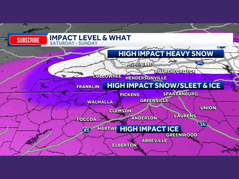
According to the impact-level forecast, western North Carolina — including areas around Asheville, Cullowhee, Hendersonville, and Rutherfordton — is currently highlighted for high-impact heavy snow, particularly closer to the mountains.
Just south of that zone, parts of upstate South Carolina, including Greenville, Pickens, Walhalla, Clemson, Anderson, and Spartanburg, are forecast to experience high-impact snow, sleet, and ice, where mixed precipitation could significantly worsen road conditions.
Farther south and east, including areas such as Greenwood, Abbeville, Hartwell, and Elberton in northeast Georgia, the primary concern shifts toward high-impact ice, which poses a serious threat to trees, power lines, and infrastructure.
Why This System Is Concerning
Forecasters emphasize that this storm is expected to produce high-impact conditions across the board, not just in isolated locations. Even small changes in the storm track could shift the snow-ice line, but the overall intensity of the system remains strong, meaning impacts are likely regardless of minor adjustments.
Ice accumulation is particularly dangerous in the Southeast, where trees retain foliage and power infrastructure is more vulnerable. When combined with snow or sleet, travel can become hazardous quickly, even on major highways.
Travel and Power Risks This Weekend
Residents across the highlighted areas should prepare for:
- Slick and potentially impassable roads
- Falling tree limbs and downed power lines
- Power outages that could last beyond the storm
- Difficult or delayed emergency response due to blocked roads
Officials caution that conditions may deteriorate rapidly, especially Saturday night into Sunday, when precipitation intensity increases.
What Happens Next
Meteorologists say first-call snowfall and ice accumulation maps are expected soon, which will help refine expected totals. Until then, residents in North Carolina, South Carolina, and northeast Georgia should closely monitor updates and prepare for high-impact winter weather that could significantly disrupt daily life.
Those in the affected areas are urged to limit unnecessary travel, charge devices, and stay informed as new forecast details are released.
Have winter weather already impacting your area or concerns about travel this weekend? Share your experience and stay updated with continued coverage at NapervilleLocal.com.

I’ve lived in Naperville long enough to see how quickly our community changes — from new developments downtown to sudden shifts in our Midwest weather. Reporting on Naperville news and daily forecasts gives me the chance to keep neighbors informed about what really matters. My goal is simple: deliver clear, timely updates so you always know what’s happening in our city and what to expect from the skies above.