
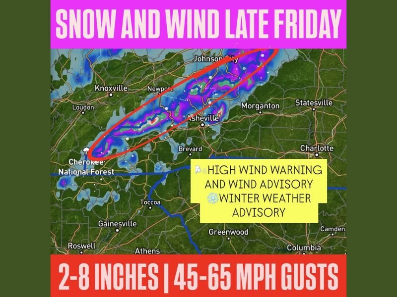
North Carolina, Tennessee and Georgia Mountain Snow Alert: Smokies Could See 2–8 Inches With 45–65 MPH Wind Gusts Late Friday Into Saturday
NORTH CAROLINA, TENNESSEE AND GEORGIA — A final (for now) surge of Arctic air is set to sweep across the Northeast and Southeast on Friday, and the favored snow zone is taking shape across the higher terrain of the Smoky Mountains, where quick-hitting snow and damaging wind gusts could combine into near-blizzard conditions late Friday into Saturday morning.
Forecast details shared with the map call for 2–8 inches of snow above 2,000 feet, with the highest, terrain-enhanced totals above 4,500 feet where more than half a foot of snow could fall. At the same time, northwest wind gusts of 45–65 mph are possible, raising the risk of power outages and dangerous travel in exposed mountain corridors.
Where the highest snow risk is focused
The guidance highlights the favored snow region as the Smoky Mountains spanning:
- Eastern Tennessee
- Western North Carolina
- Far northeast Georgia
On the map, the most active band is drawn from the Great Smoky Mountains area near Cherokee and the Nantahala region, extending northeast through the higher elevations toward Asheville and up toward the Johnson City area. Locations shown near or along this corridor include Knoxville, Newport, Asheville and Johnson City, with surrounding communities like Morganton and Statesville shown just east of the higher terrain.
The key message is elevation-driven. Lower elevations may see limited accumulation or fast-changing conditions, while the ridges and higher gaps can turn hazardous quickly once snow and wind overlap.
Snow totals: 2–8 inches above 2,000 feet, highest above 4,500 feet
The forecast attached to the graphic calls for:
- 2–8 inches of snow possible above 2,000 feet
- The most intense orographic enhancement above 4,500 feet, where more than half a foot may fall
This type of setup favors the windward slopes and ridge tops. Even if totals vary from one mountain to the next, the combination of snow, elevation and wind can produce locally severe conditions over short distances.
Wind threat: 45–65 mph gusts could create near-blizzard conditions
Alongside the snow, the map and text emphasize strong northwest winds capable of producing:
- 45–65 mph gusts in exposed terrain
- Blowing snow and sudden whiteouts on ridges and mountain highways
- Tree damage and scattered power outages, especially where winds hit saturated ground or weaker limbs
The graphic also references High Wind Warning, Wind Advisory and Winter Weather Advisory coverage for the region. While impacts will vary by exact elevation and location, winds of this strength can turn an otherwise “manageable” snowfall into dangerous conditions quickly.
Timing: Late Friday into Saturday morning, with wind lingering Saturday
The favored period for the worst overlap of snow and wind is:
- Friday evening into Saturday morning for snow and strongest impacts
- Wind continuing through Saturday, even after the steadiest snow tapers
That timing matters for travelers. Conditions can deteriorate after dark and remain hazardous into early Saturday, especially through mountain passes and higher-elevation routes.
Travel and safety impacts to watch in the mountains
Residents and travelers in the Smokies and nearby high terrain should be prepared for:
- Rapidly changing road conditions, especially near mountain gaps and ridge routes
- Lower visibility from blowing snow during peak gusts
- Downed tree limbs and isolated power outages
- Short-fuse bursts of heavier snow that can coat roads faster than expected
If you must travel through western North Carolina, eastern Tennessee or far northeast Georgia during the Friday night–Saturday morning window, the safest approach is to avoid high-elevation routes if possible, keep a winter kit in the vehicle, and plan for delays.
Pattern change next week: Warmer weather expected after this final blast
The forecast note with the graphic also points to a shift after this event: warmer weather is expected to move in next week, with above-normal temperatures likely. That suggests this round is being treated as one of the last significant winter-style punches for the region for at least the near term.
For more U.S. weather impact updates explained clearly—especially storms that can disrupt travel and families across multiple states—keep following NapervilleLocal.com and share what you’re seeing in your area.

Naperville is a community with stories that deserve to be told — both the serious ones about safety and justice, and the lighter ones that capture our culture and daily life. I focus on covering crime reports and court updates while also highlighting the traditions, events, and social trends that shape who we are. Through my reporting, I want to give readers a fuller picture of Naperville — the challenges we face and the character that keeps our city strong.