
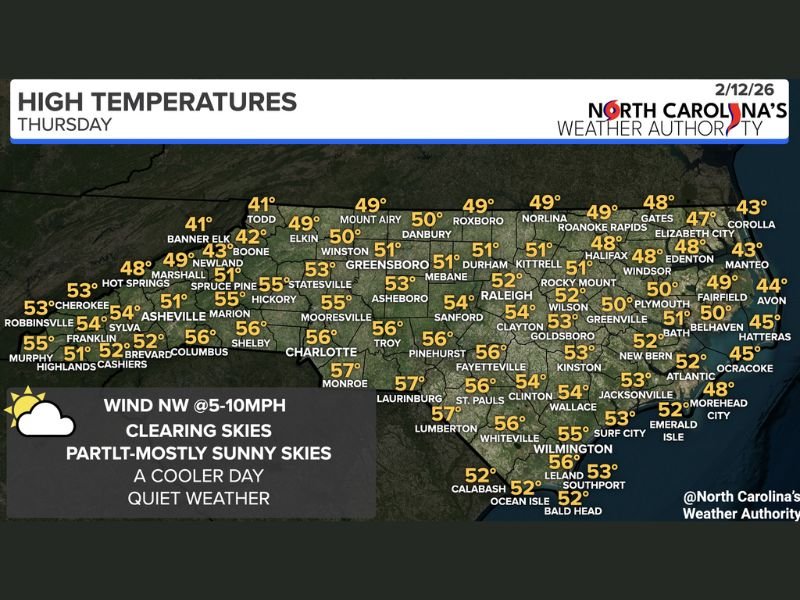
North Carolina Turns Cooler After Cold Front, Highs Range From Low 40s in the Mountains to Upper 50s Near the South Carolina Line
NORTH CAROLINA — A cold front has pushed through the state, bringing a noticeable cooldown and a return to clearing skies for Thursday, February 12, 2026. After recent unsettled conditions, much of North Carolina is now settling into a quieter pattern with partly to mostly sunny skies and afternoon highs generally in the 40s and 50s. Northwesterly winds around 5 to 10 mph will add a crisp feel to the air, especially during the morning hours.
Mountain Areas Stay Coolest
Western North Carolina will see the chilliest readings today, particularly across the higher elevations. Banner Elk and Todd are expected to top out around 41 degrees, while Boone reaches about 42 degrees. Newland sits near 43 degrees, and areas such as Marshall and Elkin are forecast to reach the upper 40s.
Asheville is projected to climb to around 51 degrees, with Hickory and Marion near 55 degrees. Murphy and Franklin should see highs in the lower to mid-50s, while Brevard and Shelby reach the mid-50s. Overall, mountain communities will notice the cooler air most prominently, but sunshine should make for a pleasant winter day.
Triad and Central North Carolina in the Low 50s
Across the Piedmont and central counties, temperatures will be slightly milder. Greensboro is forecast to reach 51 degrees, with Winston-Salem near 50 degrees. Asheboro should see around 53 degrees, and Mebane and Durham are both expected to top out at 51 degrees.
Raleigh is forecast near 52 degrees, while Sanford reaches about 54 degrees. Pinehurst and Troy are projected to climb to 56 degrees, and Fayetteville also sits around 56 degrees for the afternoon high. This region will experience clearing skies and comfortable, cool conditions — a calm break from recent changes.
Coastal Plain and Eastern North Carolina
Eastern counties will remain on the cooler side, particularly near the coast.
Rocky Mount and Wilson are expected around 52 degrees, while Goldsboro climbs to 53 degrees. Greenville should reach 50 degrees, and New Bern sits near 52 degrees.
Along the Outer Banks and immediate coastline, highs stay cooler:
- Elizabeth City: 48 degrees
- Edenton: 48 degrees
- Manteo: 43 degrees
- Avon: 44 degrees
- Hatteras: 45 degrees
- Ocracoke: 45 degrees
- Morehead City: 48 degrees
Wilmington and surrounding coastal communities such as Leland and Southport are expected to reach the mid-50s, with Wilmington around 55 degrees.
A Quiet, Cooler Day Statewide
With the cold front now past the region, Thursday brings:
- Clearing skies
- Partly to mostly sunny conditions
- Northwest winds at 5–10 mph
- High temperatures ranging from the low 40s in the mountains to upper 50s near the South Carolina border
While cooler than earlier in the week, the day remains calm and seasonable for mid-February across North Carolina. For continued regional weather coverage and detailed forecast updates from across the country, stay connected with NapervilleLocal.com.

I’ve lived in Naperville long enough to see how quickly our community changes — from new developments downtown to sudden shifts in our Midwest weather. Reporting on Naperville news and daily forecasts gives me the chance to keep neighbors informed about what really matters. My goal is simple: deliver clear, timely updates so you always know what’s happening in our city and what to expect from the skies above.