
North Carolina Turns Much Colder Monday as Wedge Setup Brings 40s and 50s, Cloud Cover and Scattered Showers Statewide
NORTH CAROLINA — A dramatically different weather pattern is settling across the state Monday as colder air returns under a classic wedge cold air damming setup, bringing mostly cloudy skies, scattered showers and much cooler temperatures compared to recent days.
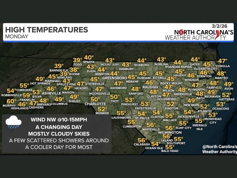
After warmer spring-like conditions, highs today are dropping into the 40s and 50s for most communities, marking a noticeable shift. Winds out of the northwest at 10 to 15 mph are reinforcing the cooler air mass across the region.
High Temperatures Fall Back Into the 40s and 50s
Across the northern and central Piedmont, temperatures are significantly cooler. Greensboro and Winston-Salem are near 44°, Durham around 45°, Raleigh near 46°, and Roxboro around 44°. Mountain communities are even colder, with Boone near 38°, Banner Elk around 39°, and Sparta close to 40°.
In western North Carolina, Asheville is near 46°, Hickory around 47°, and Marion close to 47°. These readings reflect the wedge’s influence, trapping cool air against the eastern slopes of the Appalachians.
Farther south and east, temperatures are slightly milder but still below recent highs. Charlotte is near 50°, Monroe around 52°, Fayetteville near 53°, and Laurinburg around 55°. Along the coast, readings are generally in the mid-50s, including Wilmington near 56°, Jacksonville around 55°, and Morehead City near 53°.
Mostly Cloudy With Hit-or-Miss Showers
The wedge pattern is also bringing extensive cloud cover and scattered showers throughout the day. While rainfall is expected to be light and intermittent for many locations, occasional drizzle may develop, particularly in areas where low-level moisture becomes trapped beneath the cooler air mass.
This setup is typical for March, when strong temperature contrasts and passing systems create rapid day-to-day changes. The result today is a gray and cooler feel statewide compared to the warmth experienced just days ago.
Rebound Expected Midweek
Despite today’s chill, the cooler pattern will not last long. Forecast guidance suggests a modest rebound Tuesday, followed by a stronger warm-up by Wednesday and Thursday, when spring-like conditions are expected to return.
March often brings quick swings between winter-like and spring-like air masses, and today’s wedge-driven cool-down is a clear example of that seasonal transition.
Residents should plan for a damp and cooler Monday before temperatures gradually recover later this week. For continued updates on regional weather changes and daily forecasts, visit NapervilleLocal.com for the latest reports.

I’ve lived in Naperville long enough to see how quickly our community changes — from new developments downtown to sudden shifts in our Midwest weather. Reporting on Naperville news and daily forecasts gives me the chance to keep neighbors informed about what really matters. My goal is simple: deliver clear, timely updates so you always know what’s happening in our city and what to expect from the skies above.