
North Carolina Turns Tranquil Monday With Highs in the 40s and 50s Statewide and 60s in the Mountains as Skies Gradually Clear
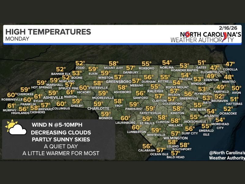
Raleigh, North Carolina — After a stretch of active weather, conditions across the state are turning much more tranquil this Monday, February 16, 2026. Forecasters expect mostly cloudy skies early, followed by gradual clearing and partly sunny conditions for many communities. High temperatures will range from the 40s along parts of the coast to the upper 50s and even low 60s in western North Carolina, marking a calmer and slightly warmer pattern heading into the week.
Light north winds around 5 to 10 mph will accompany the improving weather, helping usher in drier air and decreasing cloud cover through the day.
Mountains and Foothills Reach the Upper 50s and Low 60s
Western North Carolina will see some of the warmest readings statewide. Asheville (61°), Franklin (60°), Murphy (61°), and Cherokee (59°) are forecast to climb into the upper 50s and low 60s. Communities such as Boone (53°), Banner Elk (52°), and Spruce Pine (57°) will remain cooler but still enjoy seasonable conditions.
Further east into the foothills, Hickory (60°), Shelby (59°), and Statesville (58°) reflect the mild trend. These temperatures are slightly above average for mid-February and offer a noticeable improvement from recent unsettled weather.
Piedmont and Triangle See Comfortable Mid-to-Upper 50s
Across central North Carolina, highs will largely settle into the upper 50s. Greensboro (57°), Winston-Salem (59°), Durham (56°), and Raleigh (55°) are all forecast to enjoy a quiet, dry day with gradual breaks in the cloud cover.
Southern Piedmont cities such as Charlotte (59°), Monroe (59°), and Laurinburg (60°) will experience similar mild conditions. The calmer weather allows for outdoor activities without the concerns of heavy rain or severe storms seen recently. Skies will trend partly sunny by afternoon, especially west of the Triangle, as the atmosphere stabilizes behind departing systems.
Cooler Along the Coast, But Still Improving
Eastern and coastal North Carolina will remain slightly cooler, with highs primarily in the upper 40s to low 50s. Elizabeth City (47°), Corolla (47°), and Manteo (48°) sit on the cooler side, while New Bern (55°), Jacksonville (55°), and Wilmington (57°) edge closer to the mid-50s.
Communities along the Outer Banks, including Hatteras (51°) and Ocracoke (52°), will see lingering cloud cover but a generally dry and stable day. Conditions along the coast are expected to brighten gradually as the afternoon progresses.
Overall, Monday brings a welcome break from active weather across North Carolina. With improving skies, light winds, and seasonable to slightly above-average temperatures, the stage is set for a warming trend through the week. For continued coverage of national weather patterns and regional updates, visit NapervilleLocal.com for daily reports and in-depth analysis.

I’ve lived in Naperville long enough to see how quickly our community changes — from new developments downtown to sudden shifts in our Midwest weather. Reporting on Naperville news and daily forecasts gives me the chance to keep neighbors informed about what really matters. My goal is simple: deliver clear, timely updates so you always know what’s happening in our city and what to expect from the skies above.