
North Carolina Warms Into Near-Record 70s and 80s on February 20, 2026 as Showers, Isolated Storms and Coastal Fog Move Across the State
North Carolina — February 20, 2026 is shaping up to feel more like April than late winter, as near-record warmth surges across the state with highs in the 70s and even low 80s, while a band of broken showers and isolated thunderstorms pushes east through the afternoon.
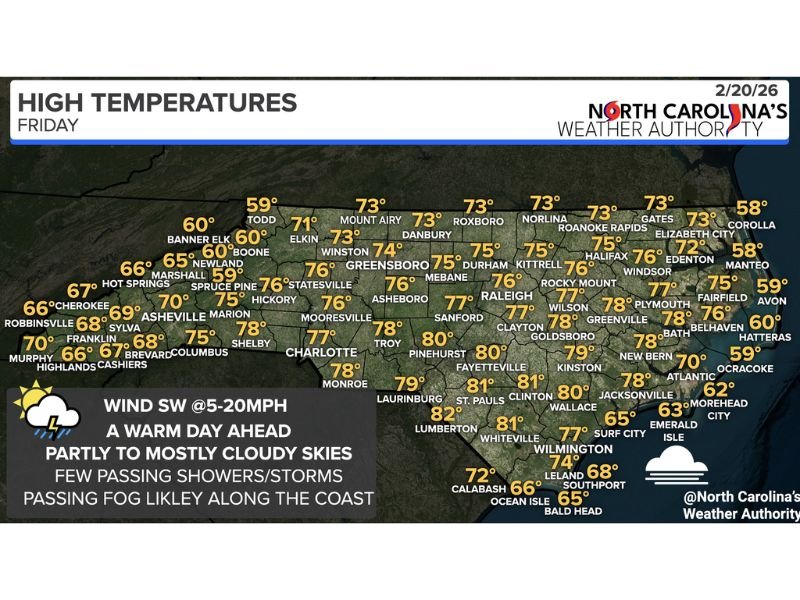
According to the forecast data provided , temperatures will climb well above seasonal norms statewide, creating an unseasonably warm end to the workweek. At the same time, residents should remain aware of passing showers, a small risk of a stronger isolated storm, and patchy coastal fog developing at times.
Near-Record Highs Spread Across the State
Much of central and eastern North Carolina will see afternoon temperatures reach the mid to upper 70s, with several southern communities touching or surpassing the 80-degree mark.
Forecast highs include:
- Raleigh: 76°
- Durham: 75°
- Greensboro: 74°
- Charlotte: 77°
- Fayetteville: 80°
- Clinton: 81°
- Lumberton: 82°
- Wilmington: 77°
In contrast, the mountains and parts of the Outer Banks remain cooler:
- Boone: 60°
- Banner Elk: 60°
- Asheville: 70°
- Elizabeth City: 73°
- Corolla and Manteo: 58°
- Hatteras: 60°
The temperature contrast highlights how widespread the warm air mass is across the Piedmont and Coastal Plain, with the warmest readings centered in southern counties. For many areas, highs in the 70s are approaching daily record territory for late February.
Passing Showers and Isolated Thunderstorms Possible
Despite the warmth, the day will not be completely dry. A band of broken showers will move west to east through the state during the morning and into early to mid-afternoon.
Forecasters indicate rainfall will generally be light and scattered. However, there remains a possibility of a brief, stronger isolated storm, particularly as daytime heating peaks.
The overall severe threat appears limited, but residents could encounter short-lived downpours, brief lightning, and gusty winds. Southwest winds are expected to range between 5 and 20 mph, adding to the spring-like feel but also creating occasional gusty conditions.
Coastal Fog and Marine Impacts
While inland areas focus on warmth and passing showers, coastal communities face another concern: fog.
Areas along the North Carolina coast may experience morning fog, with additional fog possible again in the evening. At times, visibility could become quite thick along coastal waters, potentially impacting marine travel and early morning commuters.
Communities such as Morehead City (62°), Emerald Isle (63°), Atlantic Beach (70°), and Southport (68°) could see changing visibility conditions through the day. Drivers and boaters should use caution if fog develops rapidly near waterways.
Why This Matters Beyond North Carolina
Although this weather event is centered in North Carolina, it highlights a broader late-winter pattern of above-average temperatures and unstable air masses across parts of the Southeast.
These swings can also influence travel plans, especially for Illinois residents heading south for late-winter vacations or business trips. As North Carolina closes out the week with near-record warmth, scattered showers, and patchy coastal fog, conditions are expected to remain changeable through the afternoon before improving later in the day. For more detailed regional updates, weather insights, and community coverage, continue following NapervilleLocal.com for trusted reporting and timely analysis.

I’ve lived in Naperville long enough to see how quickly our community changes — from new developments downtown to sudden shifts in our Midwest weather. Reporting on Naperville news and daily forecasts gives me the chance to keep neighbors informed about what really matters. My goal is simple: deliver clear, timely updates so you always know what’s happening in our city and what to expect from the skies above.