
North Carolina Warms Into the 50s and Low 60s With Gusty Southwest Winds as Clouds Increase Ahead of Thursday Rain
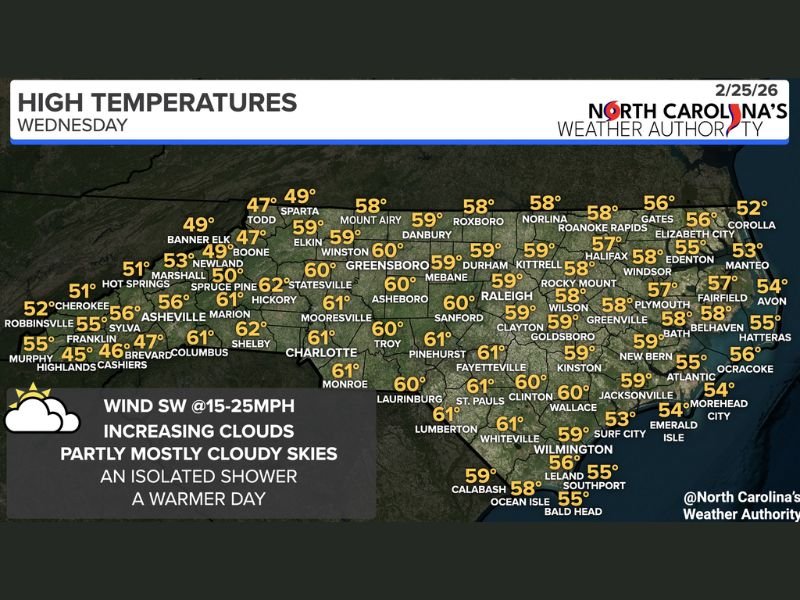
North Carolina — A shift in weather conditions is underway across the state as increasing cloud cover and gusty southwest winds bring a milder feel Wednesday, with highs climbing into the 50s and low 60s for most communities. An isolated shower cannot be ruled out today, and rain chances are expected to increase statewide by Thursday.
Forecast data shows temperatures ranging widely from the mountains to the coast. Western mountain towns such as Boone (47°), Banner Elk (49°), and Highlands (45°) remain cooler, while central and southern areas warm more noticeably. Cities including Charlotte (61°), Raleigh (59°), Greensboro (60°), Fayetteville (61°), and Pinehurst (61°) are forecast to reach the upper 50s to low 60s .
Along the coast, temperatures remain slightly cooler but still mild for late February. Wilmington (59°), Jacksonville (59°), Morehead City (54°), and Hatteras (55°) reflect the moderating influence of the Atlantic. Meanwhile, northeastern areas such as Elizabeth City (56°) and Roanoke Rapids (58°) sit in the upper 50s.
Increasing Clouds and Gusty Winds
The primary weather story Wednesday is not just the warming temperatures but the strengthening southwest wind at 15–25 mph. These gusty winds are helping pull warmer air into the region, contributing to the rise in afternoon highs across much of central and eastern North Carolina.
Cloud cover will steadily increase through the day, leading to partly to mostly cloudy skies statewide. While widespread rain is not expected Wednesday, an isolated shower remains possible, particularly as moisture levels gradually rise.
The warmer conditions are most noticeable in the Piedmont and Sandhills regions, where several communities are projected to reach 60° or slightly above. Even mountain communities are seeing modest improvement compared to recent colder stretches.
Rain Chances Increase Thursday
While Wednesday remains relatively mild and mainly dry, forecasters indicate that rain chances will expand Thursday across North Carolina. The increasing cloud cover today is an early signal of the next approaching system.
As the southwest flow continues, additional moisture will move into the state, setting the stage for broader precipitation coverage by Thursday. The exact timing and rainfall totals will become clearer with updated forecast guidance.
For now, residents can expect:
- High temperatures mostly in the 50s and low 60s
- Southwest winds at 15–25 mph
- Increasing cloud cover through the day
- A slight chance of isolated showers today
- Higher rain potential Thursday
This pattern reflects a transitional late-winter setup, with warmer air temporarily dominating before the next round of unsettled weather arrives.
For continued regional weather updates and forecast analysis, visit NapervilleLocal.com for detailed coverage and daily reports.

I’ve lived in Naperville long enough to see how quickly our community changes — from new developments downtown to sudden shifts in our Midwest weather. Reporting on Naperville news and daily forecasts gives me the chance to keep neighbors informed about what really matters. My goal is simple: deliver clear, timely updates so you always know what’s happening in our city and what to expect from the skies above.