
North Carolina Warms Into the 60s and Low 70s Wednesday as Isolated Showers and Springlike Feel Return Across the State
NORTH CAROLINA — A noticeable shift in the weather is unfolding across the state Wednesday, bringing milder air, partly to mostly cloudy skies, and a few isolated showers as temperatures climb well above average for mid-February.
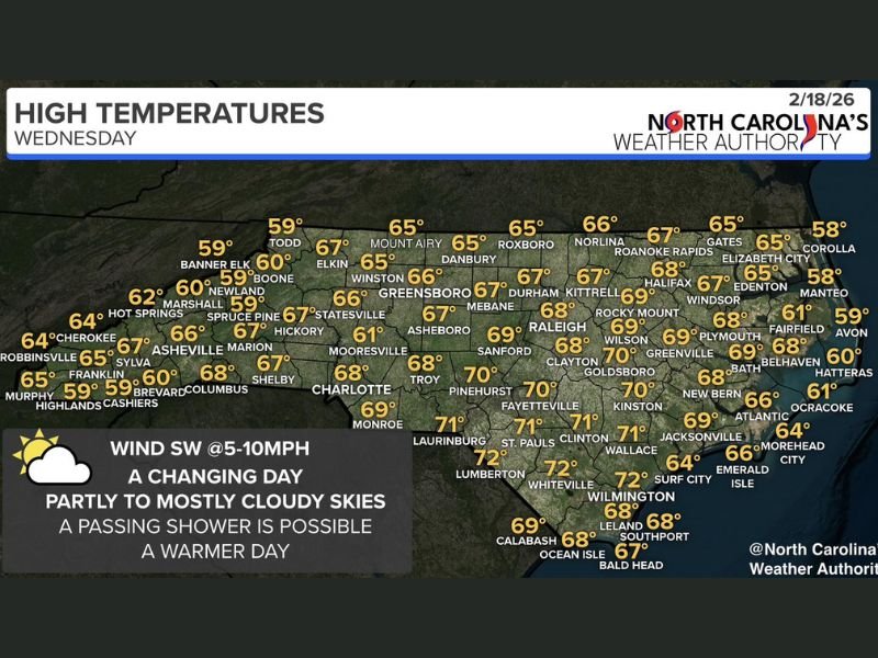
Forecasters indicate highs will surge into the 60s statewide, with several communities in central and eastern North Carolina pushing into the upper 60s and even low 70s. After recent colder stretches, the overall feel will resemble an early taste of spring.
Mountain and Foothill Communities Stay Mild
Across western North Carolina, temperatures remain comfortable for February. Cities such as Asheville (66°), Boone (60°), Banner Elk (59°), Spruce Pine (59°), and Hickory (67°) will experience seasonable to slightly above-average warmth under partly to mostly cloudy skies.
Further southwest, Franklin (65°), Murphy (65°), and Robbinsville (64°) are also forecast to sit in the mid-60s. While clouds will be present at times, the overall tone of the day remains quiet.
Piedmont Cities Climb Toward 70 Degrees
The Piedmont region will feel especially mild this afternoon.
Charlotte is expected to reach 68°, Greensboro 66°, Winston-Salem 65°, and Durham 67°. Raleigh is forecast near 68°, with surrounding areas such as Sanford (69°) and Rocky Mount (69°) approaching the 70-degree mark. South winds at around 5 to 10 mph will help boost temperatures while also contributing to the more humid, springlike feel.
Sandhills and Coastal Plain Push Into the Low 70s
The warmest air will settle across southern and southeastern North Carolina. Communities including Fayetteville (70°), Clinton (71°), St. Pauls (71°), Lumberton (72°), Kinston (70°), and Wilmington (72°) could see highs well into the low 70s.
Greenville is forecast near 69°, Goldsboro around 70°, and New Bern near 68°. Along the immediate coast, temperatures will be slightly cooler but still mild for February. Morehead City (64°), Emerald Isle (66°), Atlantic Beach (66°), and Hatteras (60°) remain influenced by the ocean.
Clouds Increase, But It’s Not a Washout
While sunshine will break through at times, skies will trend partly to mostly cloudy statewide. A few isolated showers may develop, but coverage will be limited and many communities will remain dry. This is not a stormy setup — just a passing disturbance bringing occasional clouds and a stray shower before calmer conditions resume.
A Spring Preview in February
For many across North Carolina, Wednesday will feel more like late March than mid-February. Highs in the 60s and 70s combined with light southwest winds create a comfortable and tranquil day.
Residents may notice the contrast compared to colder mornings earlier this month. With no widespread severe weather expected and only isolated shower chances, outdoor plans should face minimal disruption. We will continue to monitor upcoming systems and any changes in the extended outlook. For more regional weather coverage and daily forecast updates, stay connected with NapervilleLocal.com.

Naperville is a community with stories that deserve to be told — both the serious ones about safety and justice, and the lighter ones that capture our culture and daily life. I focus on covering crime reports and court updates while also highlighting the traditions, events, and social trends that shape who we are. Through my reporting, I want to give readers a fuller picture of Naperville — the challenges we face and the character that keeps our city strong.