
North Carolina Warms Into the 60s and Upper 60s From Raleigh to Wilmington While Mountain Towns Stay in the 50s Under Fog and Drizzle Tuesday
NORTH CAROLINA — A transition day is underway across the state as North Carolina moves toward a warmer and more extended spring-like pattern. Tuesday begins with areas of fog and patchy drizzle, but gradual clearing is expected later in the day — with noticeably milder temperatures east of the mountains.
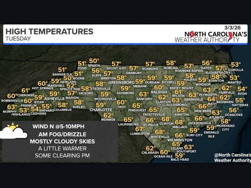
A wedge of cooler air is holding firm across parts of western and central North Carolina, keeping highs in the 50s across the foothills and mountains, while eastern and southeastern counties push into the 60s and even upper 60s.
Cooler in the Mountains and Foothills
Across western North Carolina, afternoon highs remain limited to the 50s:
- Boone, Banner Elk and Todd: around 50–51°
- Asheville and Marion: near 57–59°
- Hickory and Shelby: around 58°
- Charlotte and Mooresville: near 59°
Higher elevations such as Spruce Pine and Sparta stay closer to the lower 50s.
Morning fog and drizzle are more likely in these areas before skies remain mostly cloudy through the afternoon.
Milder East of the Triangle
Moving east of the Triad and Triangle, temperatures climb more noticeably:
- Greensboro and Winston-Salem: near 57–58°
- Durham and Raleigh: around 59–60°
- Rocky Mount and Wilson: near 61–63°
- Greenville and Goldsboro: around 63–65°
Across southeastern North Carolina, the warmest readings are expected:
- Fayetteville and Clinton: near 65–68°
- Wilmington and Whiteville: around 66–68°
- Jacksonville and New Bern: mid-60s
- Lumberton and Laurinburg: mid to upper 60s
Coastal Temperatures Moderate
Along the Outer Banks and immediate coast, temperatures remain a bit cooler due to marine influence:
- Elizabeth City: around 57°
- Manteo and Corolla: near 53°
- Hatteras and Ocracoke: mid-50s
- Morehead City and Emerald Isle: upper 50s
Winds and Sky Conditions
North winds around 5–10 mph will continue through the day. After the morning fog and drizzle, skies are expected to remain partly to mostly cloudy, with some limited afternoon clearing.
This is the final cooler wedge-influenced day before temperatures rise statewide.
Warmer Pattern Ahead
By Wednesday, most of North Carolina is expected to move fully into the 60s and 70s, marking the beginning of a more consistent warm stretch.
While Tuesday isn’t a washout, it’s a classic early-spring transition day — gray and damp early, gradually milder later.
For continued national and regional weather updates, stay with NapervilleLocal.com for the latest forecasts and pattern shifts across the country.

I’ve lived in Naperville long enough to see how quickly our community changes — from new developments downtown to sudden shifts in our Midwest weather. Reporting on Naperville news and daily forecasts gives me the chance to keep neighbors informed about what really matters. My goal is simple: deliver clear, timely updates so you always know what’s happening in our city and what to expect from the skies above.