
North Carolina Warms Into the 70s Wednesday as Morning Fog Gives Way to Sunshine and Sea Fog Lingers Along the Coast
NORTH CAROLINA — A noticeable shift toward spring-like weather is underway Wednesday as morning fog gives way to brighter skies and much milder temperatures statewide. After a foggy start in several communities, most of the state is expected to enjoy partly to mostly sunny skies with afternoon highs climbing well above recent averages.
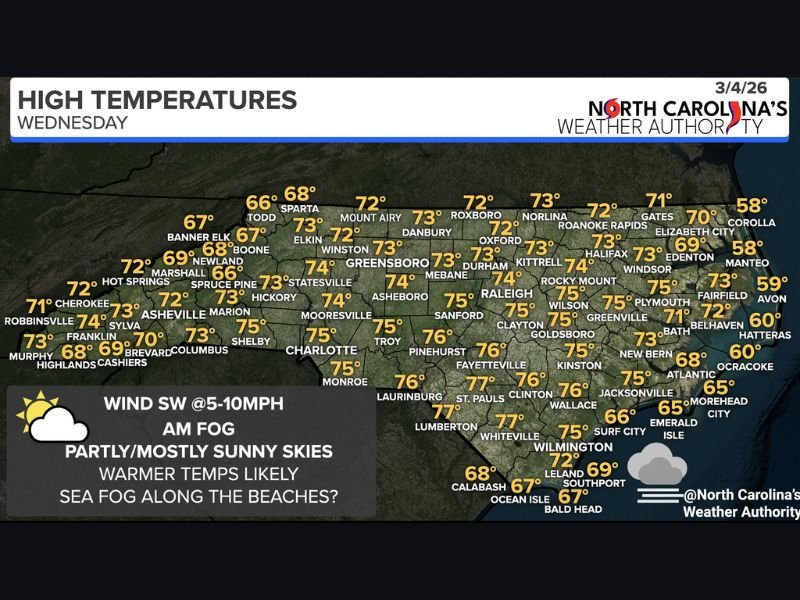
Morning Fog Before Brighter Skies
Early hours across parts of North Carolina began with areas of fog, especially in low-lying and inland communities. While visibility may have been reduced during the morning commute, improving conditions are expected as the day progresses.
Forecasters note that while inland fog will gradually lift, dense sea fog may persist along portions of the coastline, particularly near the Outer Banks and barrier islands.
Inland Highs Climb Into the 70s
Temperatures Wednesday reflect a significant warm-up across much of the state. Central and southern communities are forecast to reach the mid to upper 70s, including:
- Fayetteville and Laurinburg near 76°
- Lumberton and Whiteville around 77°
- Raleigh, Goldsboro, and Wilson near 75°
- Charlotte and Monroe around 75°
- Greensboro and Winston-Salem in the low to mid 70s
Even traditionally cooler foothill and mountain areas are warming nicely, with Asheville near 72°, Boone around 67°, and Banner Elk near 67°.
Cooler Along the Immediate Coast
While inland areas warm comfortably, coastal communities will remain cooler due to marine influences and sea fog. Highs are expected in the upper 50s to mid 60s in spots such as:
- Corolla and Manteo near 58°
- Hatteras around 60°
- Ocracoke near 60°
- Morehead City and Emerald Isle around 65°
- Wilmington near 75°, though beaches nearby remain cooler
This temperature contrast highlights the impact of onshore flow and persistent sea fog along the Atlantic coastline.
Light Southwest Winds Add to the Spring Feel
Winds from the southwest at 5 to 10 mph will help usher in the warmer air mass. Combined with increasing sunshine, the day will feel noticeably more like mid-spring than early March.
The pattern suggests more mild days ahead as the broader shift toward warmer weather continues.
Residents across North Carolina can expect a pleasant afternoon overall, with improving visibility inland and sunshine dominating much of the state. For continued regional weather updates and national outlooks, stay connected with NapervilleLocal.com.

I’ve lived in Naperville long enough to see how quickly our community changes — from new developments downtown to sudden shifts in our Midwest weather. Reporting on Naperville news and daily forecasts gives me the chance to keep neighbors informed about what really matters. My goal is simple: deliver clear, timely updates so you always know what’s happening in our city and what to expect from the skies above.