
North Carolina Weather Shift Brings 70s and 80s From Charlotte, Raleigh, Wilmington Before Cold Front Drops Temps Into 50s and 60s Tuesday
NORTH CAROLINA — A classic spring weather shift is unfolding across North Carolina today, as warm and breezy conditions give way to a cooler pattern behind an approaching cold front.
Residents across the state—from the mountains to the coast—are experiencing a mild and pleasant start, but changes are already on the horizon by this evening.
Warm and Breezy Conditions Across the State
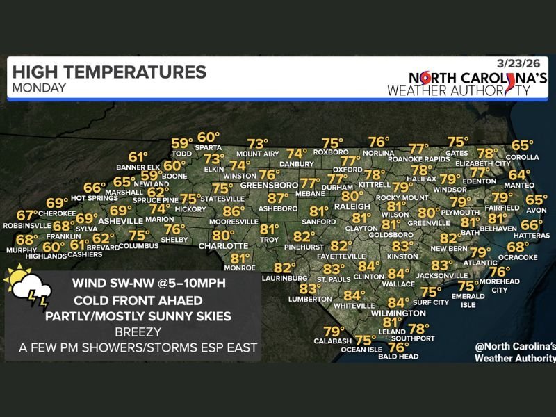
Temperatures are climbing comfortably into the 70s and low 80s statewide, with some of the warmest readings focused across central and eastern North Carolina:
- Charlotte: Around 80°F
- Raleigh: Near 80°F
- Fayetteville & Clinton: Low to mid 80s
- Wilmington: Low 80s
- Greenville & Goldsboro: Around 80–81°F
Meanwhile, cooler air lingers in the higher elevations:
- Boone: Upper 50s to near 60°F
- Asheville: Upper 60s to near 70°F
Winds are expected to remain light but breezy out of the southwest to northwest (5–10 mph), adding to the changing feel in the atmosphere.
Cold Front Approaches With Limited Moisture
A cold front is moving toward the state today, but it’s not expected to bring widespread rainfall.
Instead:
- Partly to mostly sunny skies dominate most areas
- A few isolated showers or thunderstorms may develop, especially across eastern North Carolina
- Moisture remains limited, so rain coverage will be spotty
However, forecasters note that an isolated stronger storm cannot be ruled out, with the main concern being brief damaging wind gusts.
Evening Cooldown Begins Statewide
As the cold front pushes through later today and tonight, temperatures will begin to fall across much of North Carolina.
This will lead to:
- A noticeable drop in temperatures overnight
- Cooler air settling in across all regions
- A shift in wind direction signaling the frontal passage
Much Cooler Air Arrives Tuesday
By Tuesday, the change becomes much more apparent:
- High temperatures drop into the 50s and low 60s statewide
- A significantly cooler and more refreshing feel replaces today’s warmth
- Skies remain mostly clear with dry conditions continuing
This sharp drop highlights the strong contrast often seen during springtime transitions.
What This Means for Residents
- Enjoy the warm and pleasant conditions today
- Be prepared for a cooler feel by Tuesday
- Keep an eye on the sky in eastern areas for any brief storms this afternoon
Overall, this is a fast-moving, low-impact system, but one that will bring a noticeable temperature shift across the state. Stay with NapervilleLocal.com for continued updates on changing weather patterns across the Midwest, Southeast, and beyond.

I’ve lived in Naperville long enough to see how quickly our community changes — from new developments downtown to sudden shifts in our Midwest weather. Reporting on Naperville news and daily forecasts gives me the chance to keep neighbors informed about what really matters. My goal is simple: deliver clear, timely updates so you always know what’s happening in our city and what to expect from the skies above.