
North Carolina Weather Shifts Wednesday as Cold Front Brings Rain, Mountain Snow Showers, and Sharply Colder Air Overnight
North Carolina — A changing and more active weather pattern is unfolding across the state Wednesday, as a cold front approaches from the west, bringing scattered rain showers, increasing cloud cover, and a sharp drop in temperatures by Wednesday night into Thursday. While much of the state will experience mild daytime highs, mountain areas could see rain transition to snow showers overnight, especially at higher elevations.
Forecasters say the day will start relatively quiet but grow more unsettled as moisture increases ahead of the advancing front.
Rain Develops Across Central and Eastern North Carolina
During the morning and early afternoon, scattered rain showers are expected mainly across central and eastern North Carolina. The rain will generally be light and intermittent, but residents are advised to keep rain gear handy as passing showers move through.
Western areas will remain drier by mid-afternoon, while clouds continue to thicken statewide. Forecasters note that areas from the foothills east toward Greensboro may see little to no rainfall, with the most consistent shower activity remaining farther east.
Mountain Rain Changes to Snow Showers Overnight
As the cold front pushes through Wednesday evening, additional moisture will move into the western mountains, where rain showers are expected to transition to snow showers overnight. This changeover is most likely above 3,000 feet in elevation, where colder air arrives first. While widespread accumulation is not expected at lower elevations, higher mountain communities could briefly see snow showers, especially late Wednesday night into early Thursday morning.
Temperatures Mild Wednesday, Then Turning Sharply Colder
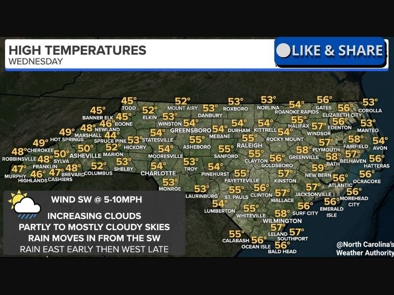
High temperatures Wednesday will range from the 40s in the mountains to the 50s across much of central and eastern North Carolina, including cities such as Charlotte, Raleigh, Durham, and Wilmington. These readings are near seasonal norms but will not last long.
Once the front passes, temperatures will drop quickly overnight, setting the stage for a much colder Thursday morning. The influx of colder air will be noticeable statewide, particularly in the western and northern parts of the state.
Clouds Increase as Winds Shift
Skies will remain partly to mostly cloudy throughout the day, with clouds thickening ahead of the front. Winds will generally blow from the southwest at 5 to 10 mph, helping push warmer air northward early before colder air arrives later in the day. As the front moves through, winds will shift and reinforce the cooling trend overnight.
What Residents Should Expect Next
By Thursday morning, North Carolina will wake up to colder conditions, with lingering mountain snow showers possible early and drier air gradually returning elsewhere. The sharper temperature drop may catch some residents off guard after a relatively mild Wednesday afternoon.
Drivers traveling through the western mountains late Wednesday night or early Thursday should remain alert for changing conditions, especially at higher elevations. NapervilleLocal.com will continue monitoring evolving weather patterns across the country and providing accurate, location-specific reporting when national systems have broader impacts.

I’ve lived in Naperville long enough to see how quickly our community changes — from new developments downtown to sudden shifts in our Midwest weather. Reporting on Naperville news and daily forecasts gives me the chance to keep neighbors informed about what really matters. My goal is simple: deliver clear, timely updates so you always know what’s happening in our city and what to expect from the skies above.