
North Dakota, Minnesota, South Carolina, and Georgia to See Dangerous 5°–10°F Wind Chills as Arctic Blast Deepens Late Sunday Into Monday
SOUTH CAROLINA — A powerful Arctic outbreak will drive dangerously low wind chills across North Dakota, Minnesota, South Carolina, and Georgia, with temperatures falling sharply Sunday night into Monday morning and wind chills dropping to 5°F to 10°F in the Carolinas and Georgia, while the Northern Plains experience punishing -20°F to -40°F conditions.
Forecast Numbers Lowered Again as Cold Deepens
Meteorologists say updated model data has pushed temperatures even lower than previous outlooks. Teens are now likely for most areas west of the South Carolina Waterway, with beaches holding near 20°F early Monday. The more significant concern, however, will be the wind chills, which are trending down to 5°–10° across the region, making for a hazardous start to the week.
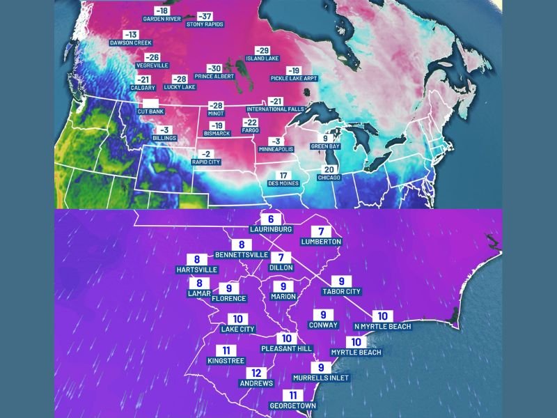
Farther north, the core of the Arctic air mass continues to deliver extreme cold. Locations along and near the U.S.–Canadian border — including International Falls (-21°F), Fargo (-22°F), and Bismarck (-19°F) — are seeing wind chills between -30°F and -50°F. This level of cold can become dangerous very quickly, especially for anyone exposed for more than a few minutes.
Northern Plains Facing the Worst of the Arctic Air
Areas from Montana through the Dakotas into northern Minnesota are firmly in the heart of the Arctic blast. Forecast wind chills Sunday and Monday show:
- Minot: -28°F
- Fargo: -22°F
- International Falls: -21°F
- Billings: -3°F
- Des Moines: 17°F
The severity of these temperatures is expected to continue through Monday morning before slowly easing into midweek.
Carolinas and Georgia Enter the Freezing Zone
While the South will not experience the extreme lows seen in the Plains, the cold remains significant by regional standards. Early Monday morning readings show:
- Laurinburg: 6°F wind chill
- Bennettsville: 8°F wind chill
- Florence: 9°F wind chill
- Conway: 10°F wind chill
- Myrtle Beach: 10°F wind chill
- Kingstree: 11°F wind chill
Actual temperatures will remain in the upper teens to low 20s across inland South Carolina and parts of eastern Georgia.
Cold Safety Urged as Region Faces Bitter Start to the Week
Officials advise residents across the Southeast and the Upper Midwest to take precautions:
- Limit outdoor exposure during early Monday morning
- Bring pets indoors, especially overnight
- Protect pipes, particularly along exterior walls
- Check on elderly neighbors and family members
With temperatures this cold, even short periods outside can lead to frostbite in northern states and hypothermia risks across the South.
A gradual warmup is expected later next week, but until then, Sunday night into Monday morning will bring some of the coldest conditions of the season across both the northern and southeastern United States. Stay with NapervilleLocal.com for continued coverage of national weather impacts.

I’ve lived in Naperville long enough to see how quickly our community changes — from new developments downtown to sudden shifts in our Midwest weather. Reporting on Naperville news and daily forecasts gives me the chance to keep neighbors informed about what really matters. My goal is simple: deliver clear, timely updates so you always know what’s happening in our city and what to expect from the skies above.