
North Florida and Georgia to See Steady Weekend Rainfall While Central and South Florida Stay Mostly Dry and Warm
FLORIDA, UNITED STATES — A new rainfall forecast from the Weather Prediction Center shows a clear split in Florida’s weekend weather pattern. While north Florida and parts of southern Georgia are expected to see steady rain through Sunday, Central and South Florida, including Miami and Fort Myers, will stay mostly dry and unseasonably warm.
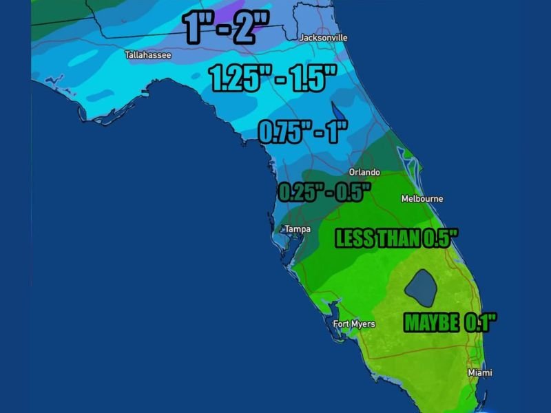
Rain Concentrated in Northern Florida and Georgia
Forecast models indicate that the heaviest rainfall will be focused in northern Florida, stretching from Tallahassee to Jacksonville, where totals between 1 and 2 inches are expected. Some isolated spots could see slightly higher amounts if showers become more persistent. The rainfall is projected to arrive Friday night and continue through the weekend as a weak frontal boundary stalls across the Southeast.
Areas farther south into Orlando, Tampa, and Melbourne may only receive 0.25 to 0.75 inches of rain, mainly from scattered light showers on Sunday. Meteorologists say that although totals won’t be excessive, travelers across north Florida and Georgia should be prepared for wet roads and reduced visibility, especially during morning and evening hours when rainfall will be most widespread.
Warm and Mostly Dry for South Florida
Meanwhile, South Florida, including Miami, Fort Lauderdale, and the Florida Keys, will experience a much different weekend. Forecasts call for only a few isolated showers and less than 0.1 inches of rainfall, keeping the region mostly dry. Afternoon highs will remain in the upper 70s to low 80s, offering a warm break compared to the cooler, cloudier conditions farther north.
The National Weather Service reports that the warm, stable air mass over southern Florida will limit storm development. However, forecasters note that a few brief coastal showers could still pop up Sunday evening before the next cold front arrives early next week. For most residents, it will be a weekend suited for outdoor plans and seasonal warmth.
Regional Weather Pattern and Outlook
The current setup reflects a typical early December pattern, with the northern Gulf states seeing wetter weather while southern regions remain under subtropical high pressure. Georgia and the Florida Panhandle will likely see the most measurable rainfall totals through late Sunday, while conditions gradually improve by Monday as the system moves eastward.
Looking ahead, meteorologists expect temperatures across Florida to stay above normal for much of next week. Any significant cool down will likely hold off until mid-December when a stronger front may reach the peninsula. For now, South Florida can expect warm, humid afternoons, while the northern half of the state deals with clouds and scattered rain.
Residents planning weekend travel should monitor local updates for changing conditions. While flooding is not expected, ponding on roadways and brief heavy showers could cause slowdowns in northern areas.
For continuous coverage of regional weather, travel impacts, and extended forecasts, visit NapervilleLocal.com for the latest updates.

I’ve lived in Naperville long enough to see how quickly our community changes — from new developments downtown to sudden shifts in our Midwest weather. Reporting on Naperville news and daily forecasts gives me the chance to keep neighbors informed about what really matters. My goal is simple: deliver clear, timely updates so you always know what’s happening in our city and what to expect from the skies above.