
North Georgia Storm Update: Severe Thunderstorms Weaken Late Night as Warnings Expire Around Atlanta, Gainesville, and Rome
NORTH GEORGIA — The severe weather threat that moved across parts of north Georgia Monday evening has begun to wind down, with storms weakening late at night and previously issued warnings allowed to expire across the region.
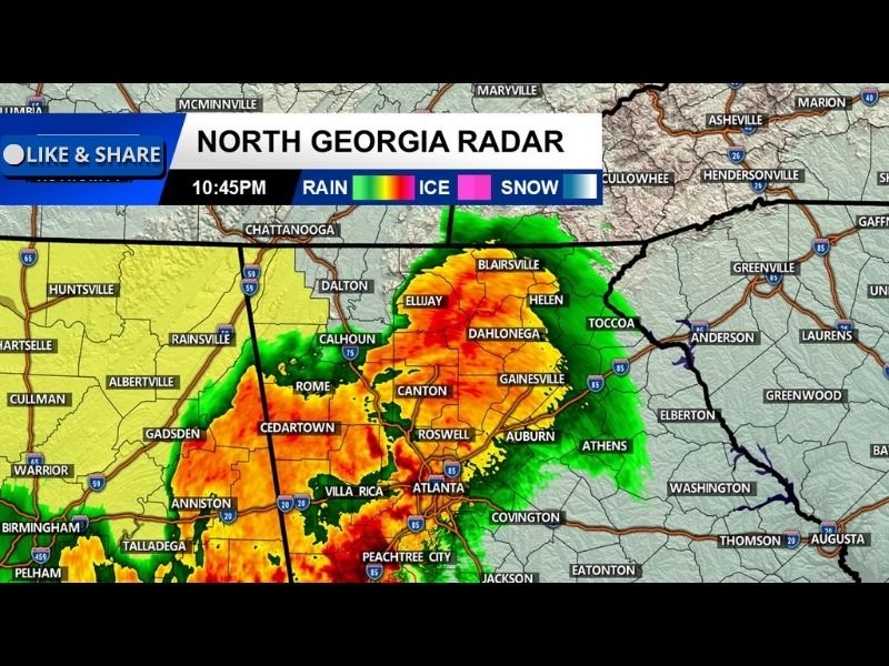
Radar imagery around 10:45 PM showed a large area of heavy rain and thunderstorms stretching across much of north Georgia, including communities around Atlanta, Gainesville, Canton, Dahlonega, Ellijay, and Rome. While storms remained active on radar, the most intense severe weather conditions earlier in the evening had diminished as the system gradually weakened.
Strong Storms Moved Across Northern Georgia
Earlier storms pushed across several north Georgia communities, producing heavy rainfall and thunderstorms across the region.
Radar indicated widespread storm activity moving across areas such as:
- Atlanta
- Gainesville
- Canton
- Dahlonega
- Ellijay
- Rome
- Villa Rica
- Cedartown
These storms formed a broad cluster across northern Georgia, bringing periods of intense rain and lightning as they moved through.
Storm Warnings Expire as System Weakens
As the night progressed, the thunderstorms that had prompted earlier warnings gradually weakened. Weather officials allowed the warnings to expire once the storms began losing intensity and the immediate severe weather threat decreased.
Although the system still produced heavy rainfall in places, radar trends showed that the storms were no longer maintaining the severe characteristics seen earlier in the evening.
Rain Continues Across Parts of the Region
Even though the severe threat diminished, radar continued to show areas of rain and thunderstorms across north Georgia late Monday night.
Communities across the region could still experience occasional lightning and moderate rainfall as the system continued moving east. Cities including Atlanta, Gainesville, Dahlonega, and Ellijay remained under bands of rain on radar during the late-night hours.
Severe Weather Threat Now Diminishing
Meteorologists say the overall severe weather setup responsible for the storms is gradually weakening, reducing the likelihood of additional severe warnings overnight.
Residents across north Georgia can expect storms to continue tapering off as the system moves away from the region. Weather officials encourage residents to continue monitoring forecasts and radar updates overnight, although the primary severe weather threat appears to be coming to an end across the area.

I’ve lived in Naperville long enough to see how quickly our community changes — from new developments downtown to sudden shifts in our Midwest weather. Reporting on Naperville news and daily forecasts gives me the chance to keep neighbors informed about what really matters. My goal is simple: deliver clear, timely updates so you always know what’s happening in our city and what to expect from the skies above.