
Northeast States Expected to Receive 6–7 Inches of Snow Through Weekend, NOAA Model Shows Widespread Accumulation
New York — A widespread winter storm is expected to deliver 6 to 7 inches of snow across several Northeast states through the weekend, according to the latest NOAA blend of weather models. The system, which is forecast to intensify as it moves across the region, may produce hazardous travel conditions and slick roads from New York and Pennsylvania to parts of New England.
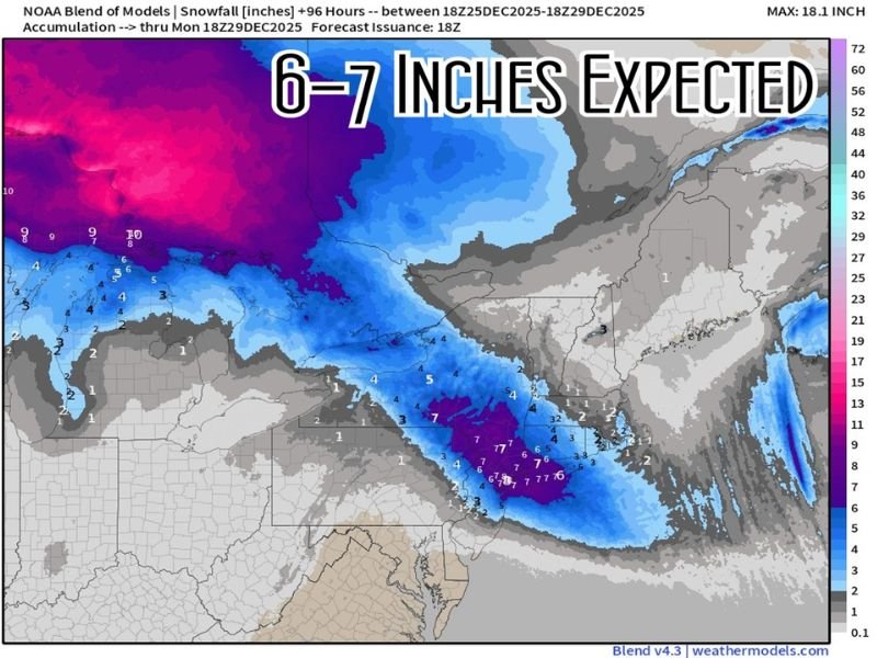
NOAA Model Projects Widespread 6–7 Inch Snowfall Across the Northeast
The new NOAA model blend highlights a large corridor of moderate to heavy snowfall, stretching from the eastern Great Lakes region through northern Pennsylvania, upstate New York, and into portions of New England. Many communities fall within the 6–7 inch accumulation zone, with isolated higher amounts possible depending on localized snowfall bands.
The storm window, shown in the model period between December 25 and December 29, indicates that snow will spread over multiple days, increasing the likelihood of steady accumulation rather than short-lived bursts.
Areas shaded in deeper blue and purple tones on the forecast map represent regions most likely to receive significant weekend totals, creating a long-duration winter event rather than a brief system.
Travel Disruptions Likely as Snow Intensifies Through the Weekend
With several inches of snow expected, forecasters warn that holiday weekend travel may be impacted across the Northeast. Roadways may become slick and snow-covered, particularly in interior sections of New York, Pennsylvania, Vermont, and Massachusetts, where the heaviest totals are concentrated.
Drivers should anticipate:
- Slower travel times
- Reduced visibility during heavier bands
- Snow-packed roads in rural and higher-elevation areas
- Potential airline delays due to widespread winter weather
Early preparation—such as adjusting travel plans or allowing extra time—is recommended for residents who will be commuting or returning home after holiday gatherings. The NOAA model emphasizes that while many regions will see 4–5 inches, a broad swath is firmly within the 6–7 inch zone, indicating a consistent and high-confidence snowfall forecast.
What Residents Should Know and Prepare For
As the weekend approaches, residents in the impacted states should monitor updated forecasts and prepare for conditions that may shift depending on temperature trends and storm track adjustments.
Key preparations include:
- Ensuring vehicles have winter-ready tires and emergency kits
- Clearing outdoor walkways to prevent ice buildup
- Planning for possible school or service delays on Monday
- Monitoring local advisories as the system progresses
The snowfall is expected to taper early next week, with conditions improving after the main energy of the system moves offshore. However, forecasters caution that secondary impacts, such as drifting snow and colder air behind the system, could prolong minor travel issues in rural areas.
Looking Ahead as the Region Enters a More Active Pattern
Meteorologists note that this storm may signal the beginning of a more active winter pattern for the Northeast as year-end weather systems become more frequent. With temperatures trending colder, future storms may bring additional snow opportunities into early January.
Residents are encouraged to stay updated through reliable weather sources as new model runs refine snowfall projections and potential advisories. For continuing winter weather alerts, snowfall forecasts, and regional travel updates, follow NapervilleLocal.com for accurate and timely reporting.

I’ve lived in Naperville long enough to see how quickly our community changes — from new developments downtown to sudden shifts in our Midwest weather. Reporting on Naperville news and daily forecasts gives me the chance to keep neighbors informed about what really matters. My goal is simple: deliver clear, timely updates so you always know what’s happening in our city and what to expect from the skies above.